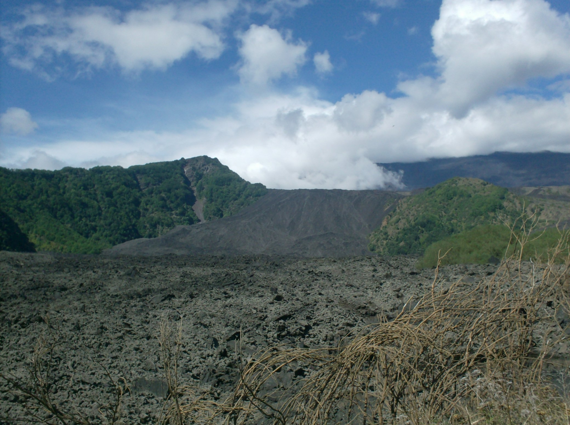
Simeto's lava canyons
37°41'39.60"N 14°48'34.15"E SP 94 Crossroads to the Saraceni Bridge (1 km farther)
These gorges are gorges that have been formed by...


This report was almost entirely realized taking inspiration from Giovanni Vallone's award-winning book "Guida dell'Etna"
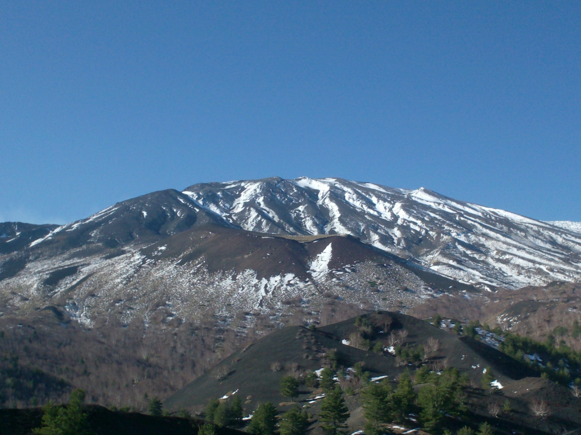
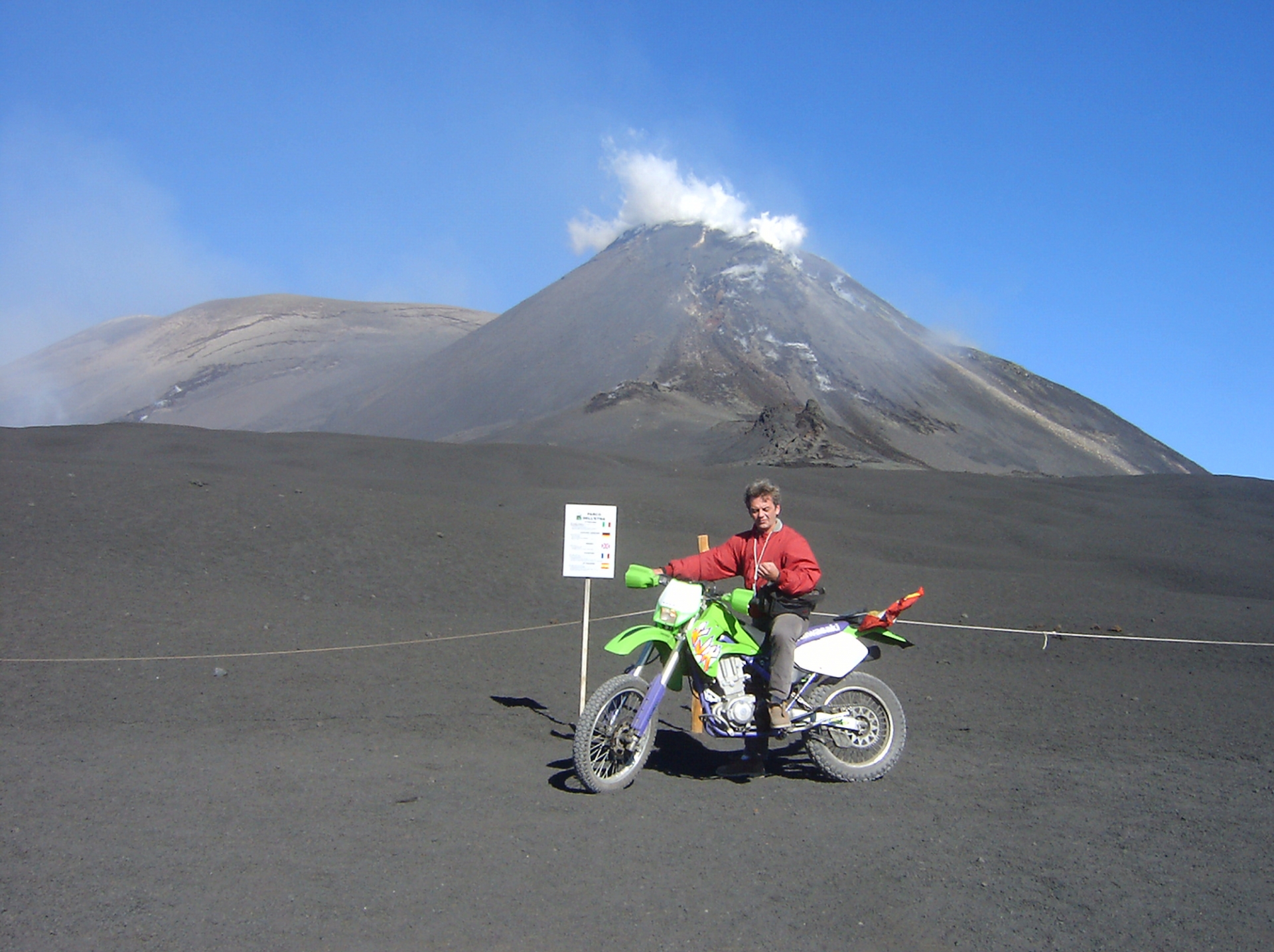
The Queen of Sicily who with her 3330 m. represents the highest volcano in Europe.
Queen and not King, because for the Sicilians the Etna is a woman: "the mountain (a muntagna, in Sicilian) Etna" eith the female article "la"; and not ,"the volcano Etna", with the male article "il", as it would be more correct to say.
From the height of its 3300 meters, like a huge sitting Buddha in the eastern part of Sicily, the highest volcano in Europe scrutinizes the Sicilians and ... Paradise.
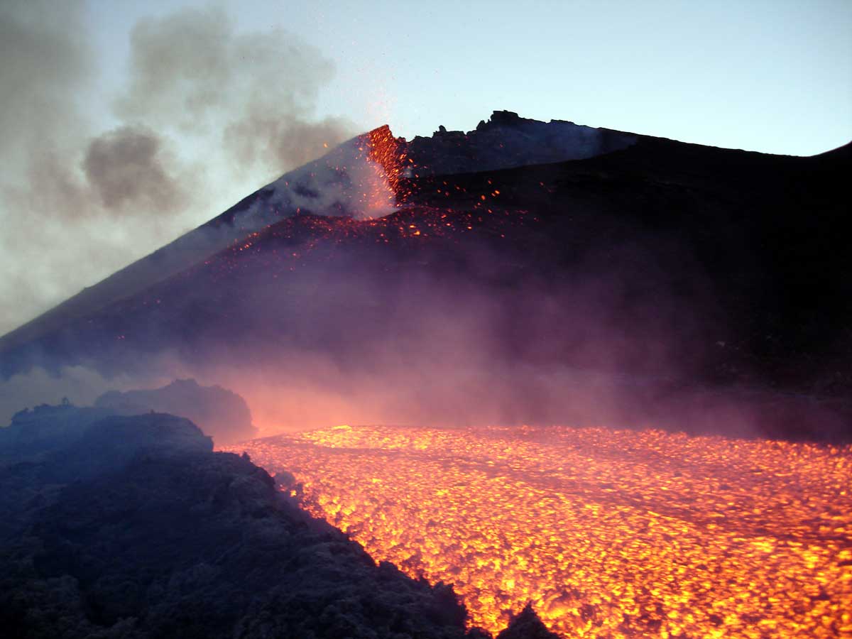
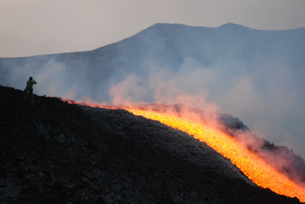
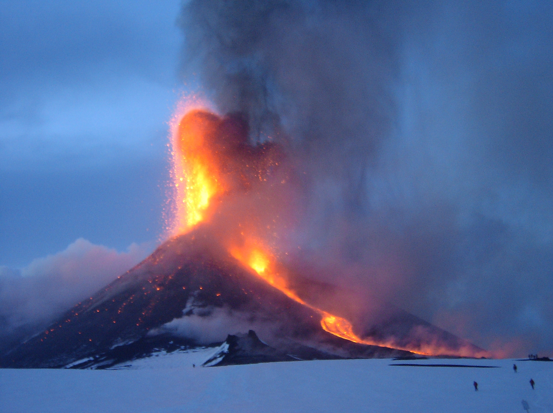
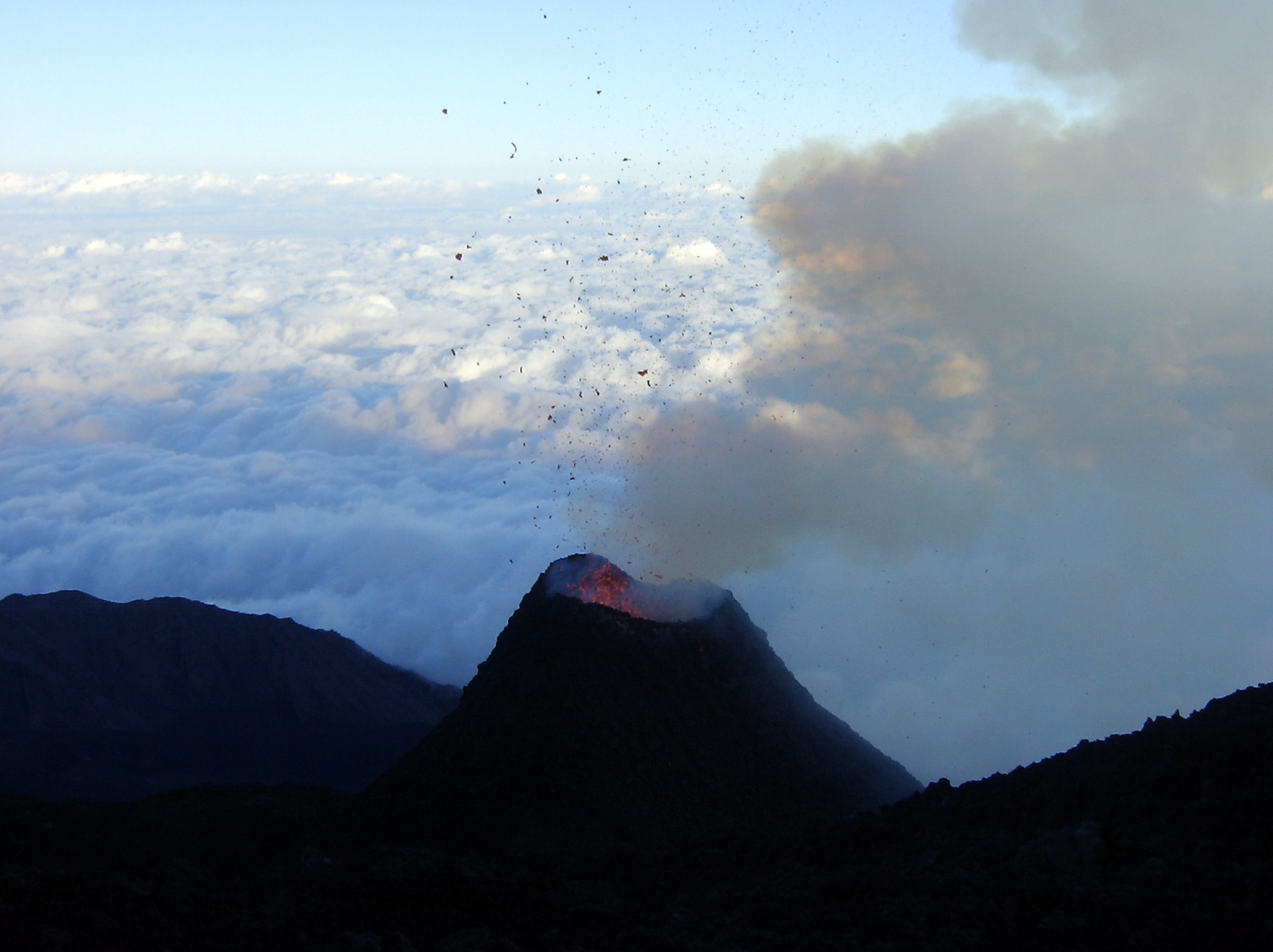
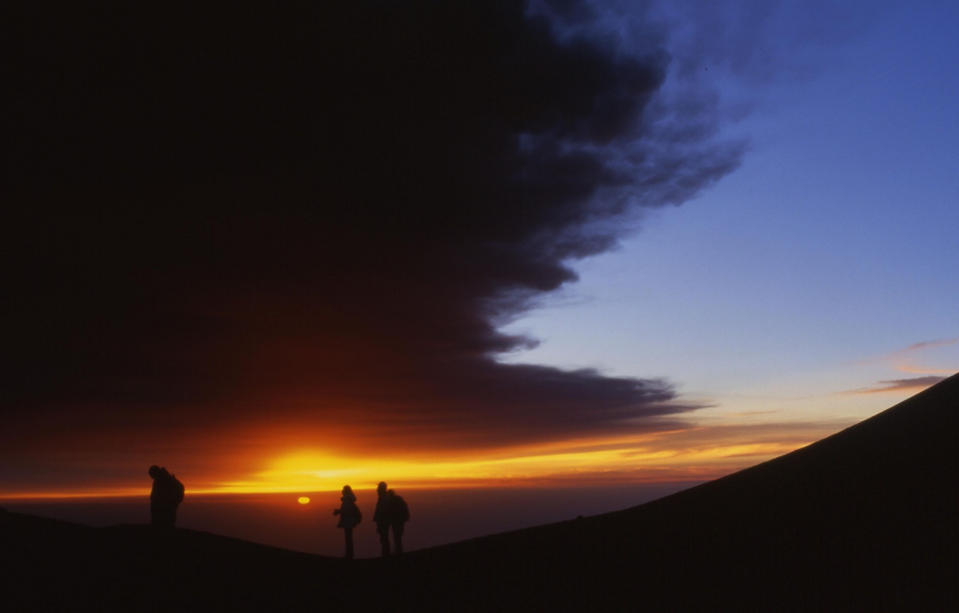
Is a very very high mountain that occasionally spits fire.
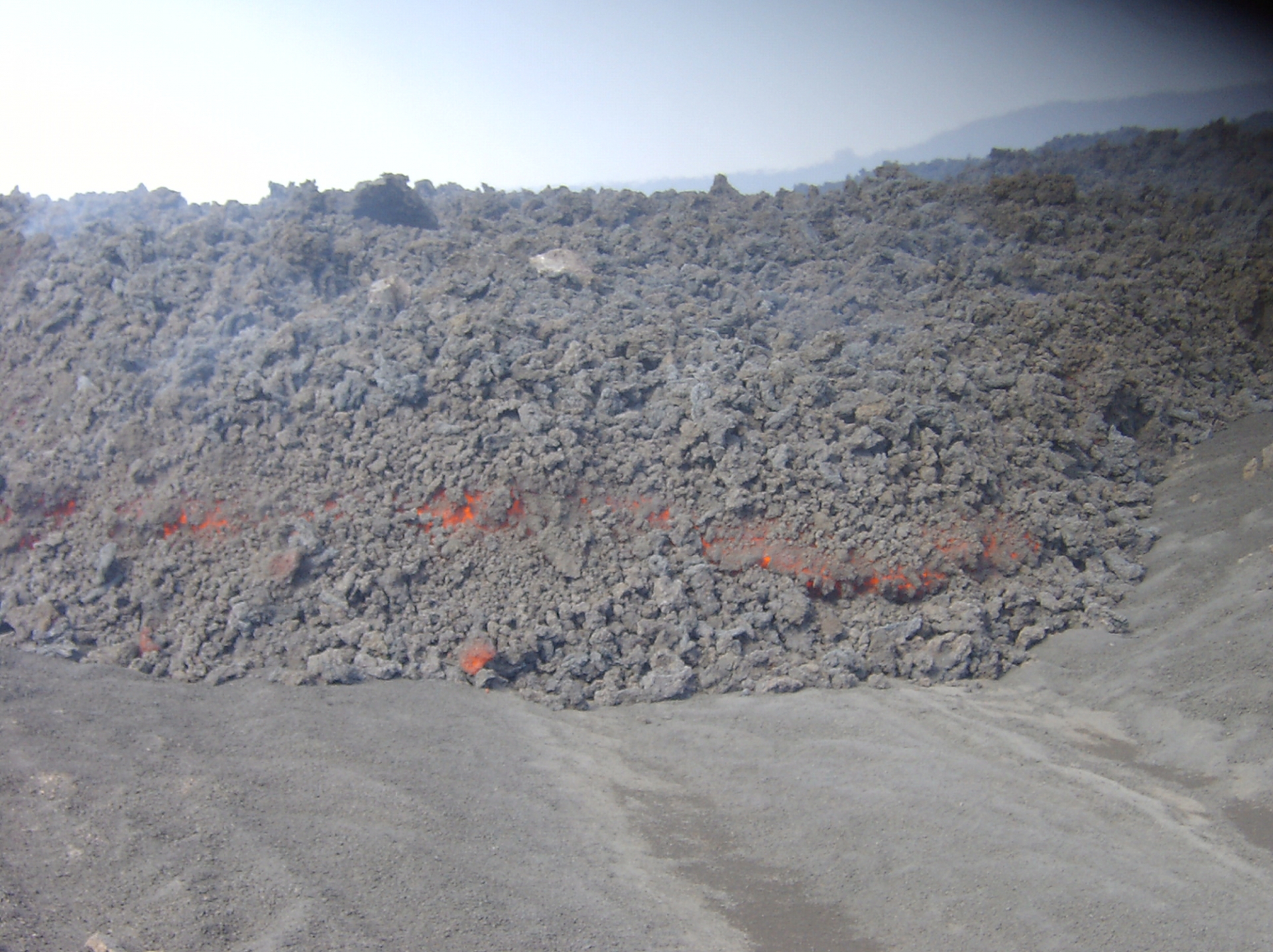
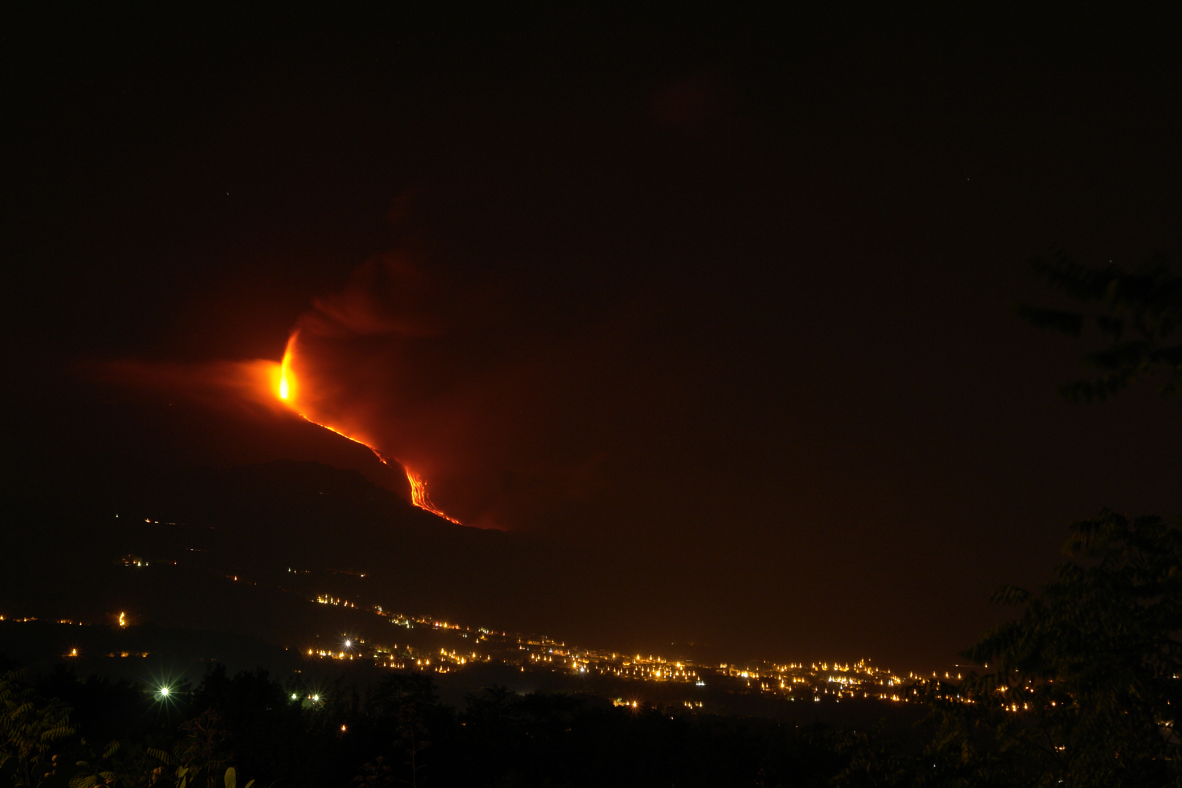
Fire that becomes river, fountain, lake ... giving breathtaking eruptions that can be seen hundreds of kilometers away.
The land of Sicilians, living on its slopes, trembles!
They immediately run in the squares or on the balconies of the houses to enjoy this wonderful spectacle of nature: fireworks in the sky!
Etna is an active volcano and does nothing to prove otherwise!
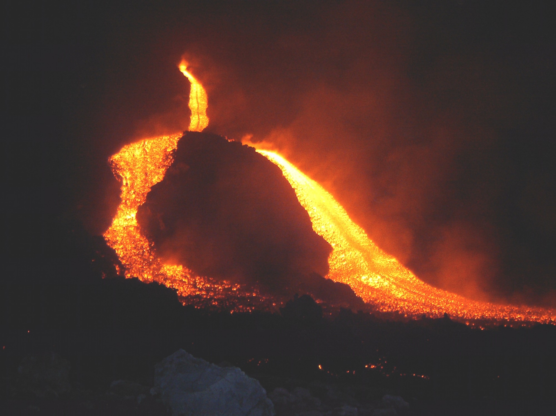
The luck of being on holiday in these parts while the Sicilian giant has decided to launch fire and flames is an extraordinary experience.
Don't worry, we have not gone crazy: Etna is not dangerous, because the craters of the top are very far from inhabited centers (the closest is 1000 meters above sea level) and the lava river, as fast as you want, will take months to reach the first houses (but this does not mean that it could not happen) and therefore there is plenty of time to organize a "forced relocation"!
.JPG)
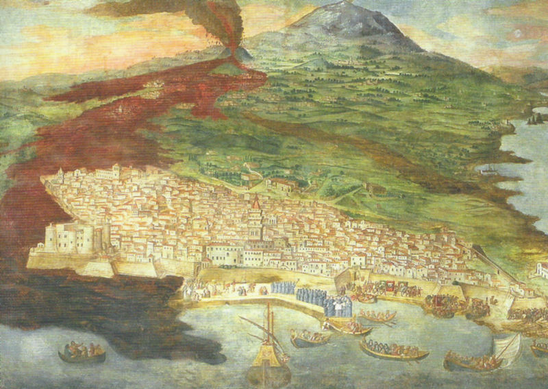
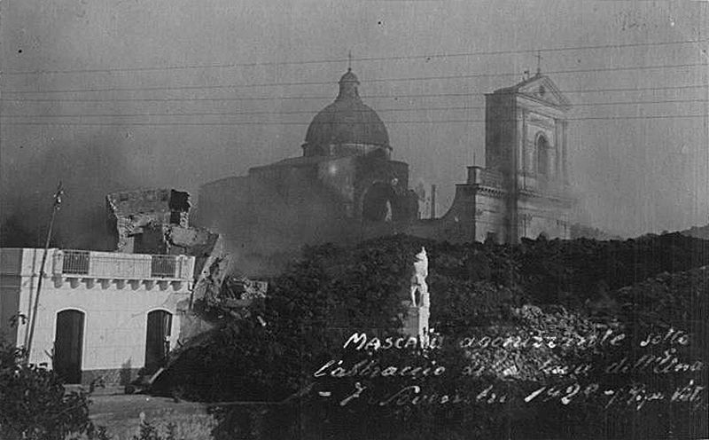
The last major eruption occurred in 1928 when the lava reached a step away from the sea (in the municipality of Mascali).
And in 1991 Zafferana Etnea had very bad moments, with the fiery snake that grazed the inhabited center after having destroyed countryside houses in the surroundings of Zafferana Etnea.
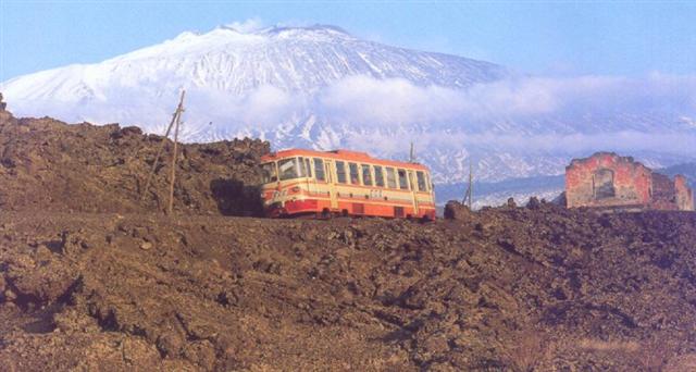
Etna is a destination in the destination and travelers often come to Sicily just for her, to see her at least once in her life. His visit is one of the Sicilian experiences not to be missed: extinct craters, caves, woods, lava flows, houses submerged by magmas of the past, lunar landscapes ... thrill the overwhelmed visitors.

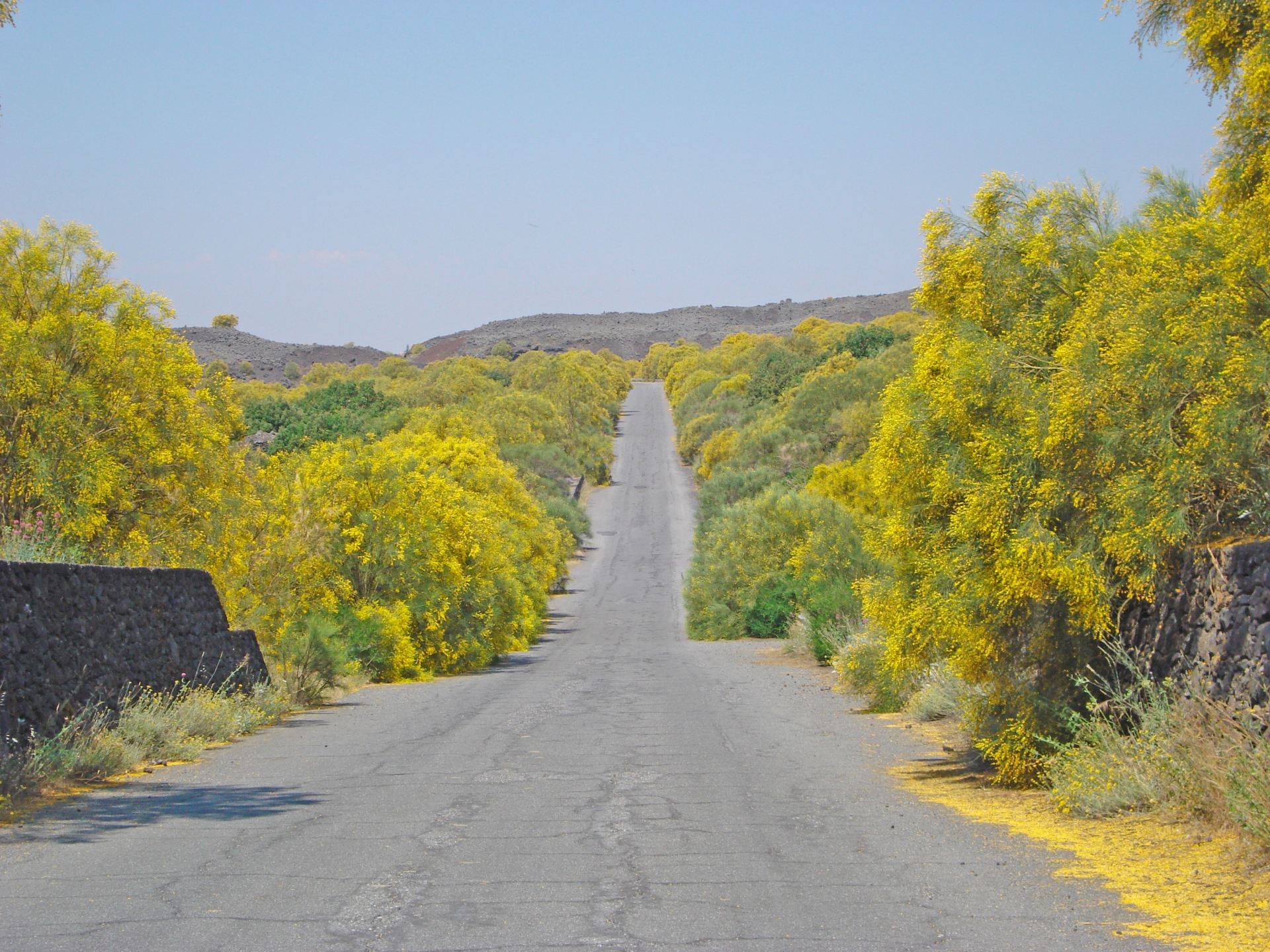
The flora is present, as well as with typical crops (pistachio, apples, hazelnuts, grapes, olives ...) also with: pines, beeches, birches, chestnuts, oaks ... and above all with one of the symbols of the volcano, the beautiful and endemic Ginestra dell'Etna (photo), splendid with its fragrant yellow flowers.
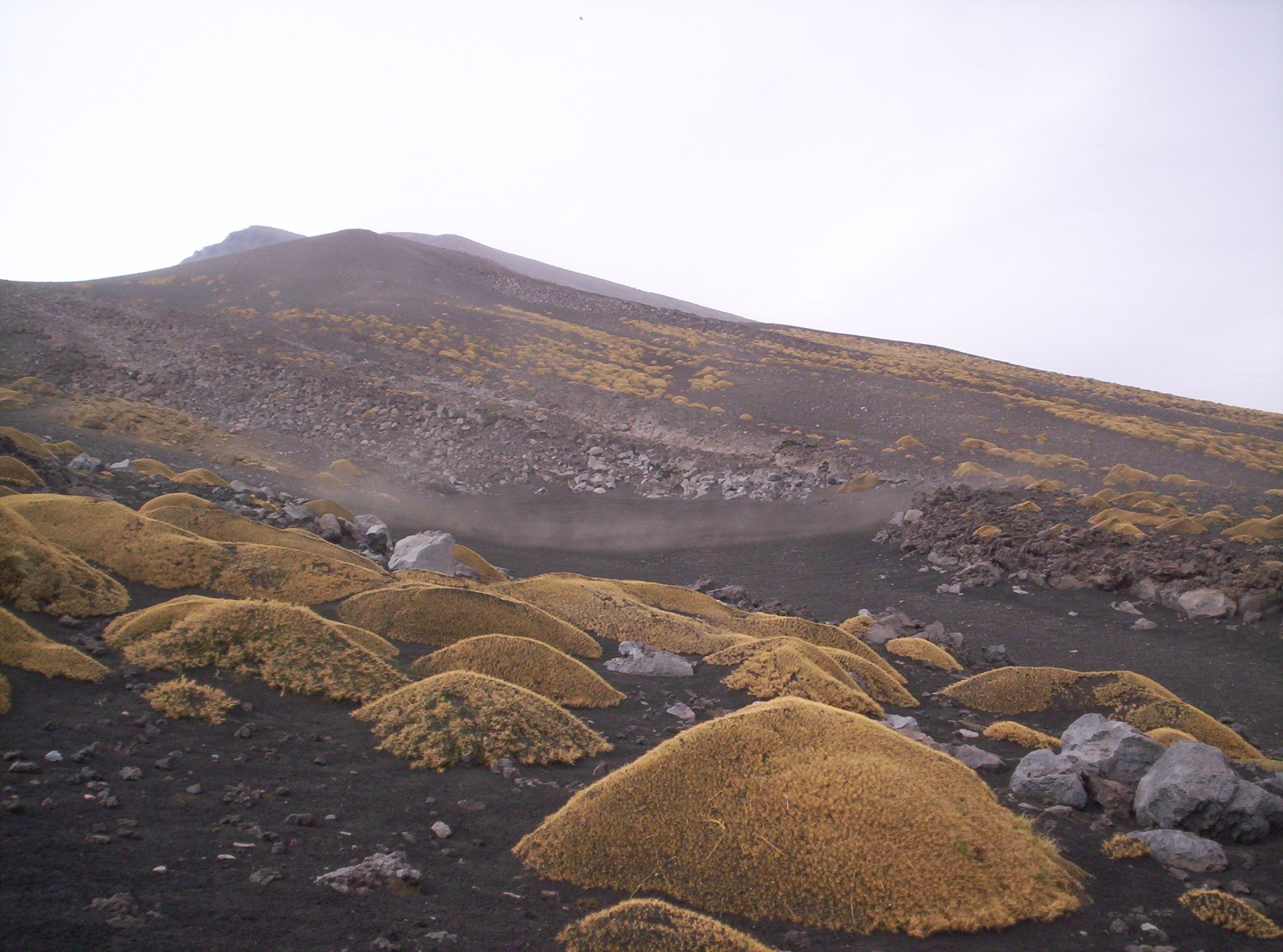
Above 2000 meters vegetation gives way to the sciara, to the lava fields.
Etna becomes Moon, brushstroke here and there by the spiked tufts of Astragal, arid and mysterious like the black and sharp lava stone on which they rest.

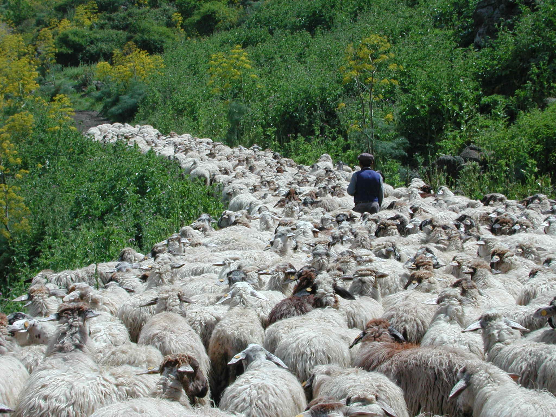
The animals are present with rabbits, hares, martens, weasels ... and the very shy wild cat.
There is no lack of breeders, as this river of sheep in the picture confirms us.
Are you ready for a volcanic experience?
On Etna, basically, there are only two roads, both of which reach 2000 meters above sea level, the most accessible point from a car: one road is to the south-east and the other to the north.
Let's go through them together.
SP92 MARENEVEFUOCO
It links the two villages of Nicolosi and Zafferana Etnea, both at about 700 meters asl, passing through the 2000 meters of Piazzale Sapienza, the highest point in the Southern side that is possible to approach by car.
Gorgeous views of the Ionian sea and the below panorama of towns, valleys, inactive craters scattered here and there, can be enjoyed from this road.
The SP92 has been traveled, even if not in the same spot of today, over the centuries, not to mention in the millennia, by thousands of travelers: from Empedocles, to Roman emperors, to Goethe and to us today.
Driving the road you can notice that in some places the road is totally new, just built after an eruption that has cut it off somewhere.
Let's go!
Nicolosi – Piazzale Sapienza (2000 metri) – Zafferana Etnea
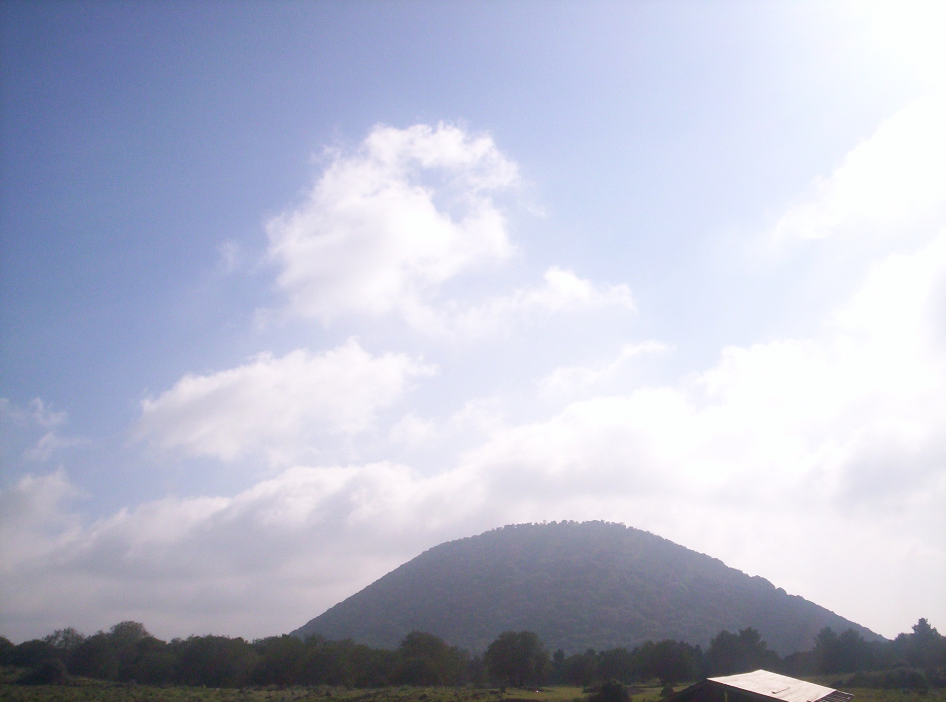
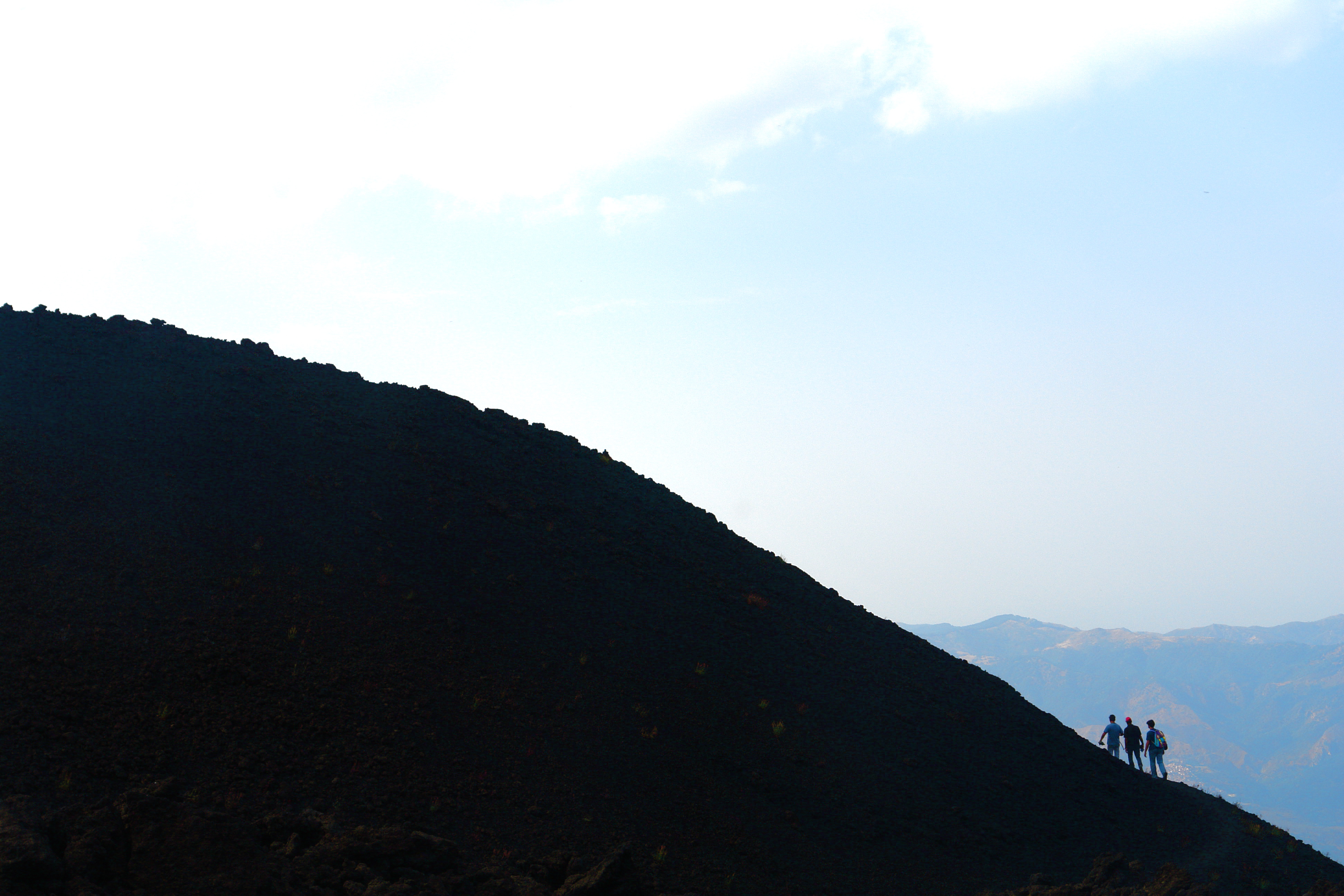
KM SP 0 – Nicolosi: beginning of the SP92-Marenevefuoco. The road begins its climb. The lava stone clearly dominates the landscape architecture: houses, streets, fences, panoramas. The beautiful silhouette of the Monti Rossi, designed by travelers from all over the world and from all times begins to appear.
KM SP 2,4 – One of the two entrances of Monti Rossi

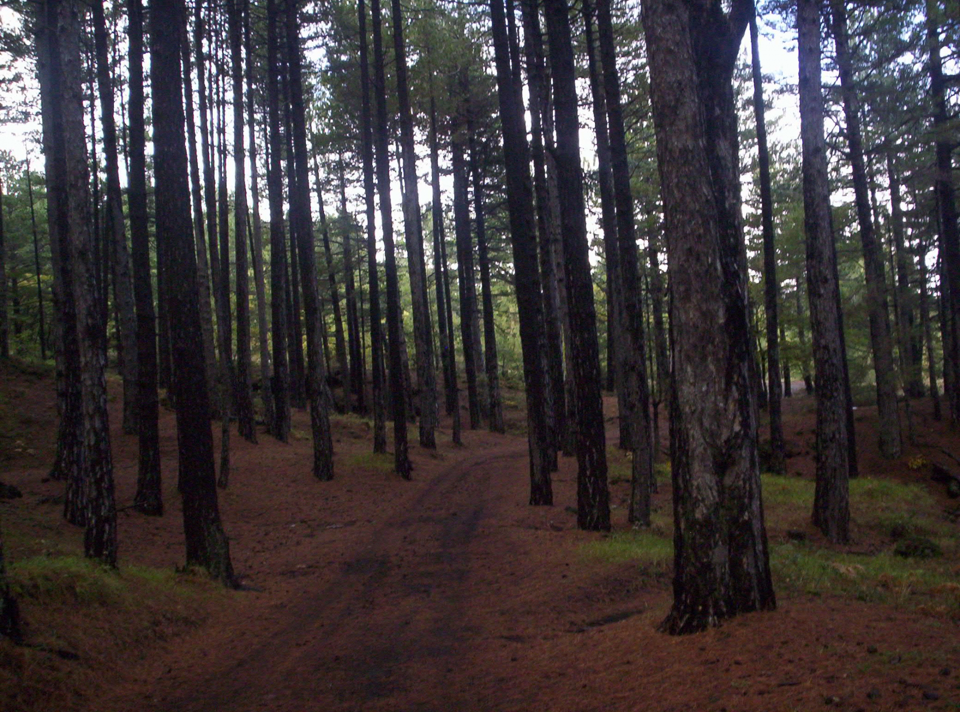
KM SP 2,7 – On the left is a deviation that leads, after 1 km, to the main entrance of the Monti Rossi. From this inactive volcano started the eruption that in 1669 destroyed the city of Catania. Today the Monti Rossi have a beautiful pine forest inside. Going up to the top you can easily imagine the path that the lava made to get to Catania: the Etna town, in fact, looks right in the center of the viewfinder.
KM SP 3,5 – The Marenevefuoco is now surrounded by the lava flow of 1910 and by tufts of Etna's Broom, the characteristic plant of the volcano, with its very fragrant yellow flowers. Beautiful Etna in front. It will always be this way in this road characterized by a wide curve radius that will make one of the most comfortable mountain roads in the world.
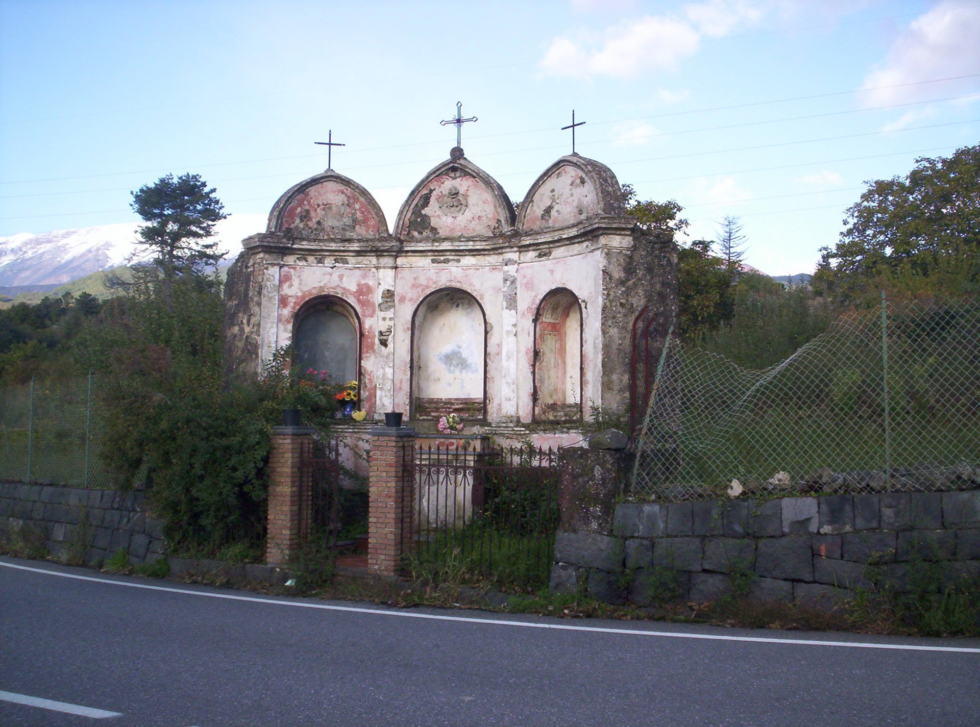
KM SP 6,0 – A typical lava stone altar on the left of the road. These small altars are placed as a sign of thanks for the arrest of a lava flow.
KM SP 7,2 – On the left is the entrance to visit Monte San Leo (1200 m.) which can be visit in just an hour. It is in correspondence of the fracture that in 1693 destroyed Catania. A comfortable walk allows you to ascend the top.
KM SP 8,0 – Here and there some typical house made by lava stone
KM SP 8,9 – On the left a bar indicates the lower entrance to Monte Sona. After Monte Sona the road still offers a beautiful view of the underlying Ionian coast thanks to the presence of a beautiful panoramic point.
KM SP 10,6 – Main entrance to Monte Sona and Monte Manfrè. Beautiful viewpoint.
KM SP 11,2 – Still on the left, upper entrance to Monte Manfrè. The SP92 continues now alternating wonderful views of lava grounds of the past, views of the summit of Etna and the underlying sea. Typical, strung between the 1983 lava flow, a sort of "islands of vegetations", above all chestnut trees, absolutely unique in their contrast with the basalt black.
KM SP 14,6 – 1720 a.s.l. On the left an interesting deviation initially immersed in a chestnut grove. This road goes into the Serra La Nave district. After 800 meters on the right a small church. Another 200 meters and you arrive at the Grande Albergo del Parco refuge. The road at this point forks.
Going left: after 700 meters is the Ariel Refuge and after 200 meters from this, on the right, is the Cancello Milia, the southern entrance to the Pista Altomontana. Then the road continues until it joins several countries.
Going to the right: after 300 meters the Astrophysical Observatory is on the left; after 550 meters, always on the left, the entrance for the Monte Nero degli Zappini nature trail and on the right Monte Vetore (the view from up here is beautiful, with a view of the entire Ionian coast). Then the road joins the SP92 again
KM SP 16,8 – Detour to the left for Monte La Nave. Main entrance to the Monte Nero degli Zappini path (after 200 meters on the right).
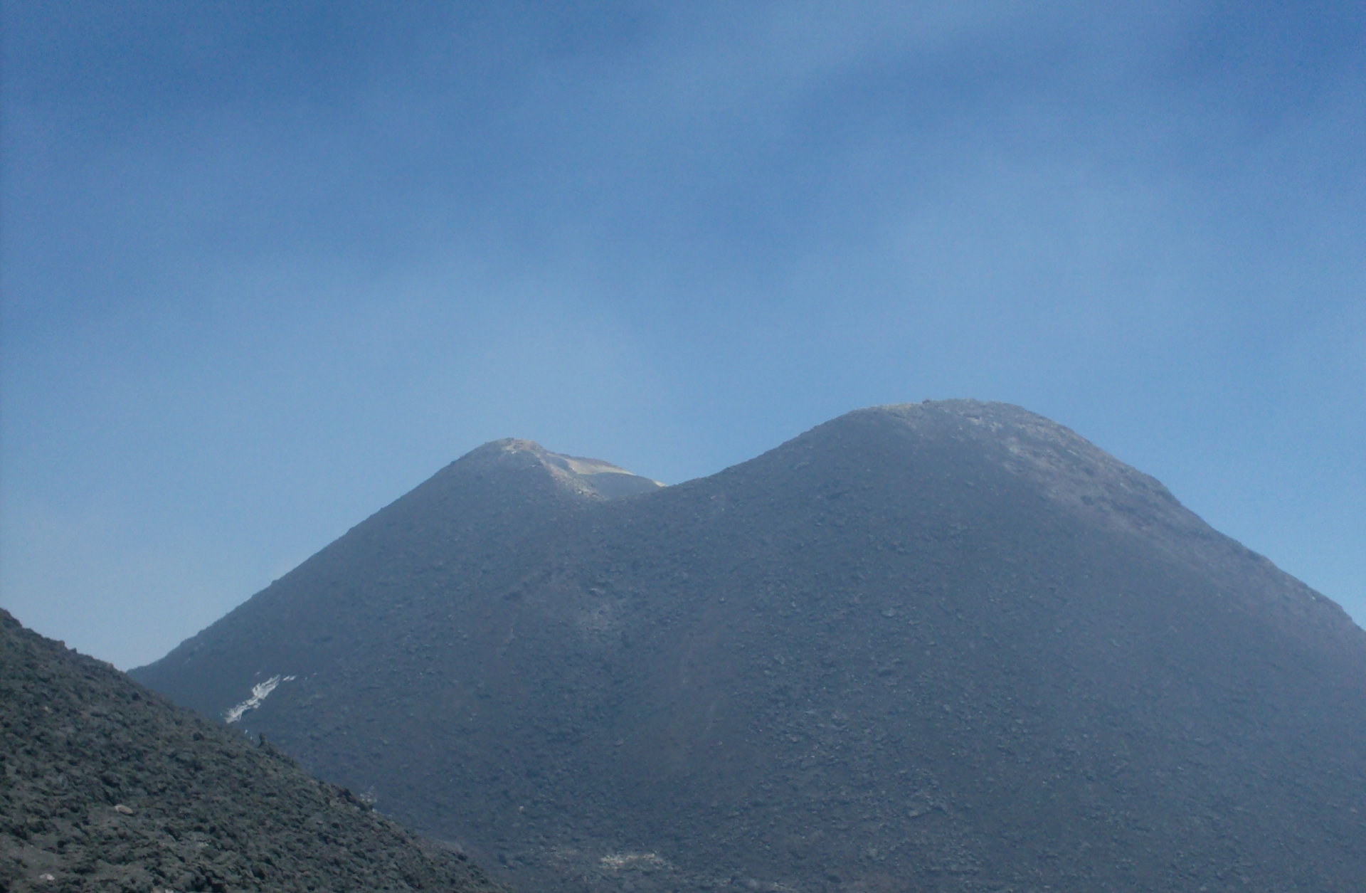
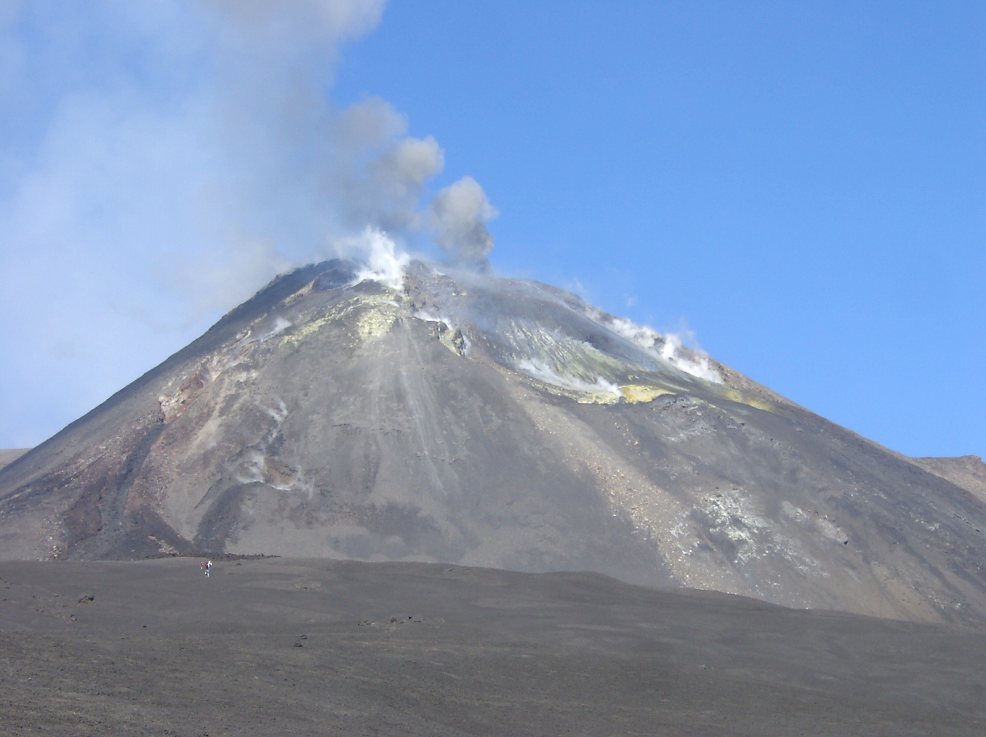
KM SP 19,2 – 1900 m asl: Piazzale Sapienza. The road reaches its highest point. The vegetation is a memory, here it is all black. There are refreshments, accommodation and souvenir shops. From this point departs the cable car (which currently reaches up to 2500 meters above sea level) and a walking track that reaches the central craters. In the Piazzale Sapienza the silhouettes of the two beautiful Silvestri craters stand out: one large and one small. The ring walk of one of the two is inevitable.
* For the laziest there is (until eruption destroys it again) the possibility of taking at 2000 m. (Piano Provenzana or Piazzale Sapienza) the cable car and with this climb up to about 2500 m. From here on, continue on foot to the top; or, but currently only from the south side there is the possibility of continuing with off-road vehicles (of the cableway management company) up to 3000 m. The last 300 meters of the summit must necessarily be covered on foot (about an hour).
KM SP 21 – Leaving Piazzale Sapienza, the Marenevefuoco begins its descent towards Zafferana Etnea.We are in the Casa del Vescovo district and on the right is the road that, along ancient lava flows, reaches Pedara, Trecastagni ... while on the left is the entrance to the Schiena dell'asino path.
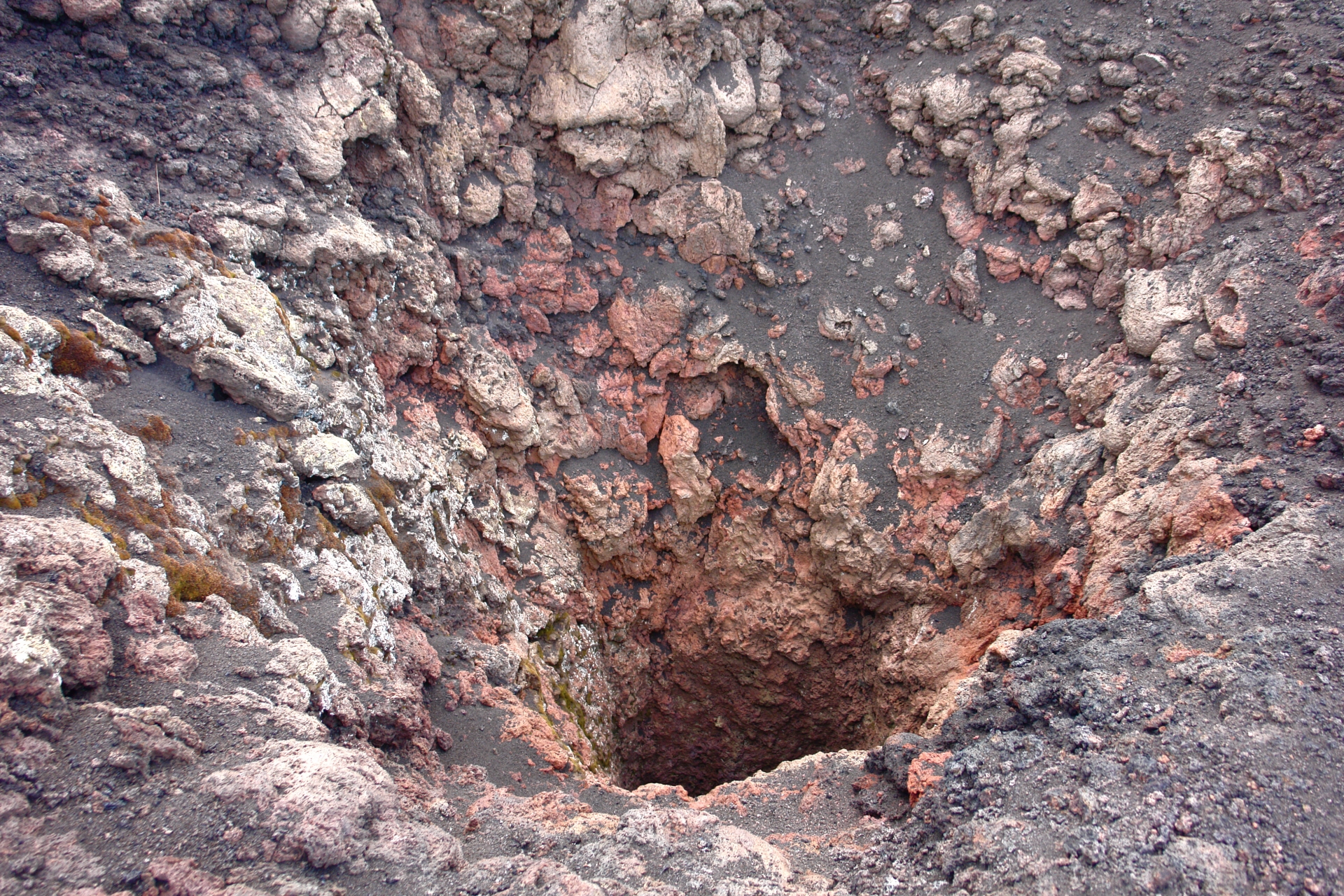
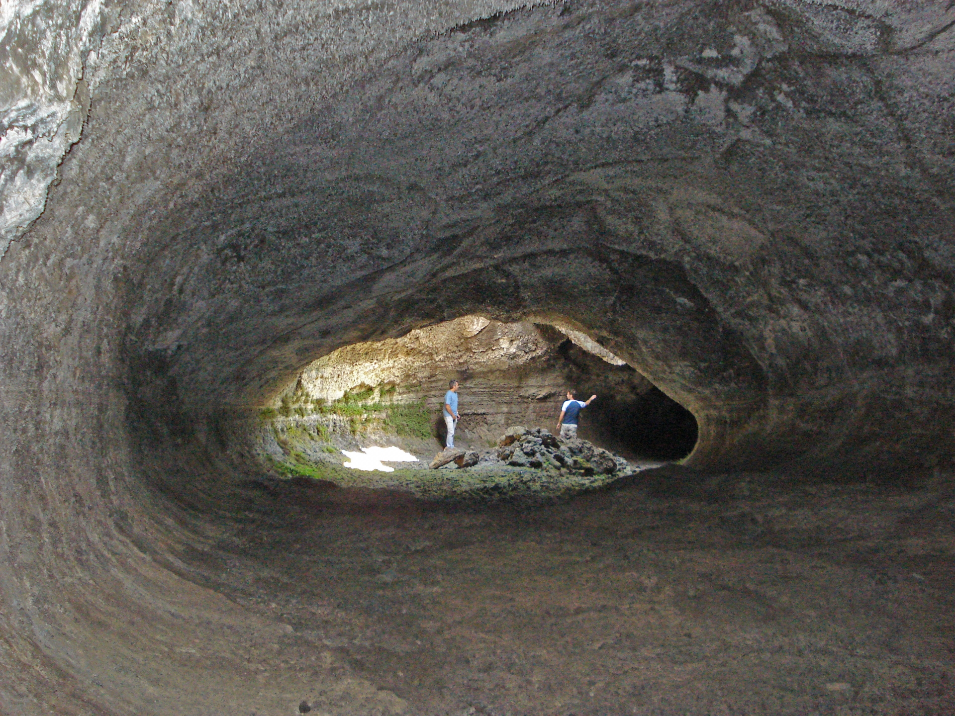
KM SP 23,6 – On the left, near the road, is the entrance to the Grotta dei Tre Livelli. More precisely: the pedestrian entrance is slightly further upstream (about 20 meters in air line) than the one clearly visible from the road (descendable with a rope).
KM SP 26,5 – We continue to go down surrounded by the lava of 1792 and on the left, near the road, the entrance to the Cassone cave.
KM SP 30 – We are about 1250 m. and on the left is the detour to Monte Zoccolaro. This road passes through beautiful Etna apple orchards and after about 5 kilometers it ends (if it continues it would plunge into the Valle del Bove). Or better: on the left continues a bumpy dirt road (which would join at the SP92-Marenevefuoco). Fifty meters after the beginning of this dirt road, on the right, the path to Monte Zoccolaro begins.
KM SP 33,2 – Among chestnut woods and the first suburban houses, on the right is the entrance to the Gatto cave.
KM SP 39 –Arrival in Zafferana Etnea.
SR FORNAZZO-LINGUAGLOSSA
Coming from Milo, a few hundred meters before the square d
of the villages of Fornazzo, on the left, there is a detour that unequivocally indicates the road to the Citelli Refuge, Etna, several nature trails ...
It is the so-called SR Mareneve, which after about 20 kilometers reaches Piano Provenzana (1900 m asl) and then descends back to Linguaglossa.
Together with the aforementioned SP92 Marenevefuoco, it is the only road that reaches such high altitudes. Currently less touristy than the other but, certainly, of greater charm, given by the perfect alternation of silences, colors and landscapes, passing through woods, lava flows and the invincible beauty of the Taormina headland on the horizon. With a clear sky, the mainland (Italy) seems right here. Several points of interest along the path of this other Mareneve.
Here we go!
N.B : Missing, at the time of our inspection, the milestones, we placed Fornazzo at KM 0 and Linguaglossa at KM 30.
KM 0 – Entrance of the Mareneve from Fornazzo. We are at about 1000 meters of altitude. As soon as you are on the left, there is a small terrace on the street with a small fountain from which fresh, clear water flows. It is a good rest area and we also recommend filling the water bottle, which is always convenient in the mountains. The road starts to climb between the vegetation and very few houses, strictly built in lava stone
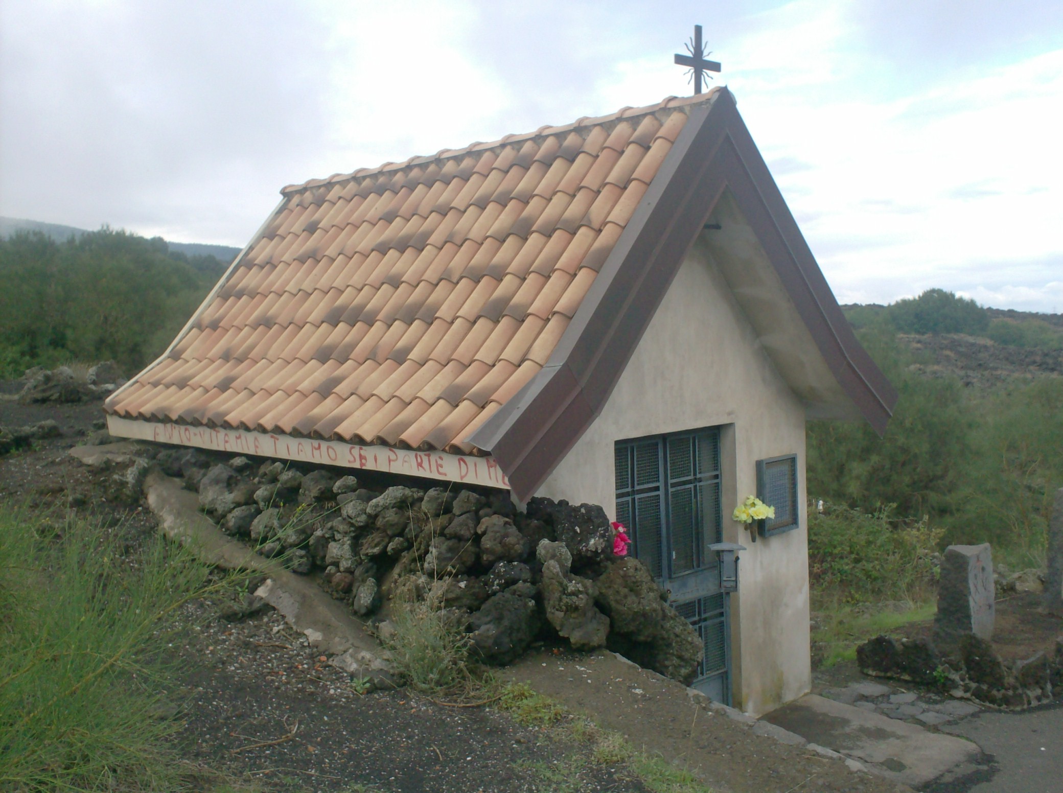
KM 1,4 – On the right a small chapel erected in 1976 in memory of the 1950 lava flow that didn't approach to Fornazzo. But what makes this place of God particularly fascinating is the 1979 lava flow that stopped right behind the altar, as can be seen both from the outside and from the inside (leaning the face to the small window). This lava tongue that descends from the mountain, tucked in the woods, is clearly visible on the left (northwest).
KM 1,6 – On the left is a small road that, coming through the woods, arrives after 1.3 km at the Casa Pietracannone (see below). The SR instead continues immersing itself in a dense forest of chestnut trees that alternates with the lava flows of the past.
KM 2,5 – We are at an altitude of 1100 meters. The view widens majestically on the Ionian coast and the mainland, which can be seen perfectly on clear days. At the edge of the road is the lava flow that reached up to Mascali in 1928. The vantage point from up here is perfect for imagining the lava river that hit the village. Along the way, different "dagal", characteristic islands with vegetation surrounded by lava. Now the lava flows on both sides of the road alternate with the panorama of Taormina, the queen of Sicilian beauty, where everything is miraculously perfect: even the view of Etna.
KM 3,1 – Now the road is immersed again inside a beautiful and dense forest of chestnut trees, pines and holm oaks.
KM 6,0 –The SR Mareneve has a deviation on the right for Sant'Alfio, Ripa della Naca ... Going along this direction, after about a couple of kilometers you meet the small Sanctuary of Magazzeni, erected in 1958 by the inhabitants of Sant'Alfio as a sign of thanks to have been not destroyed by the lava flow during the eruption of 1928 that approached Sant'Alfio very closely
KM 6,5 – We are at an altitude of about 1300 meters and on the left the entrance to the Pineta della Cubania, the starting point for various itineraries. Red circlet!
KM 7,0 – Once past the Cubania, the road, now immersed in a panorama of chestnut trees and turkey oaks, offers a beautiful window on the Ionian coast.
KM 8,1 – 1400 m. asl., we reach the Bosco della Cerrita. A green bar on the right indicates the entrance of a nature trail.
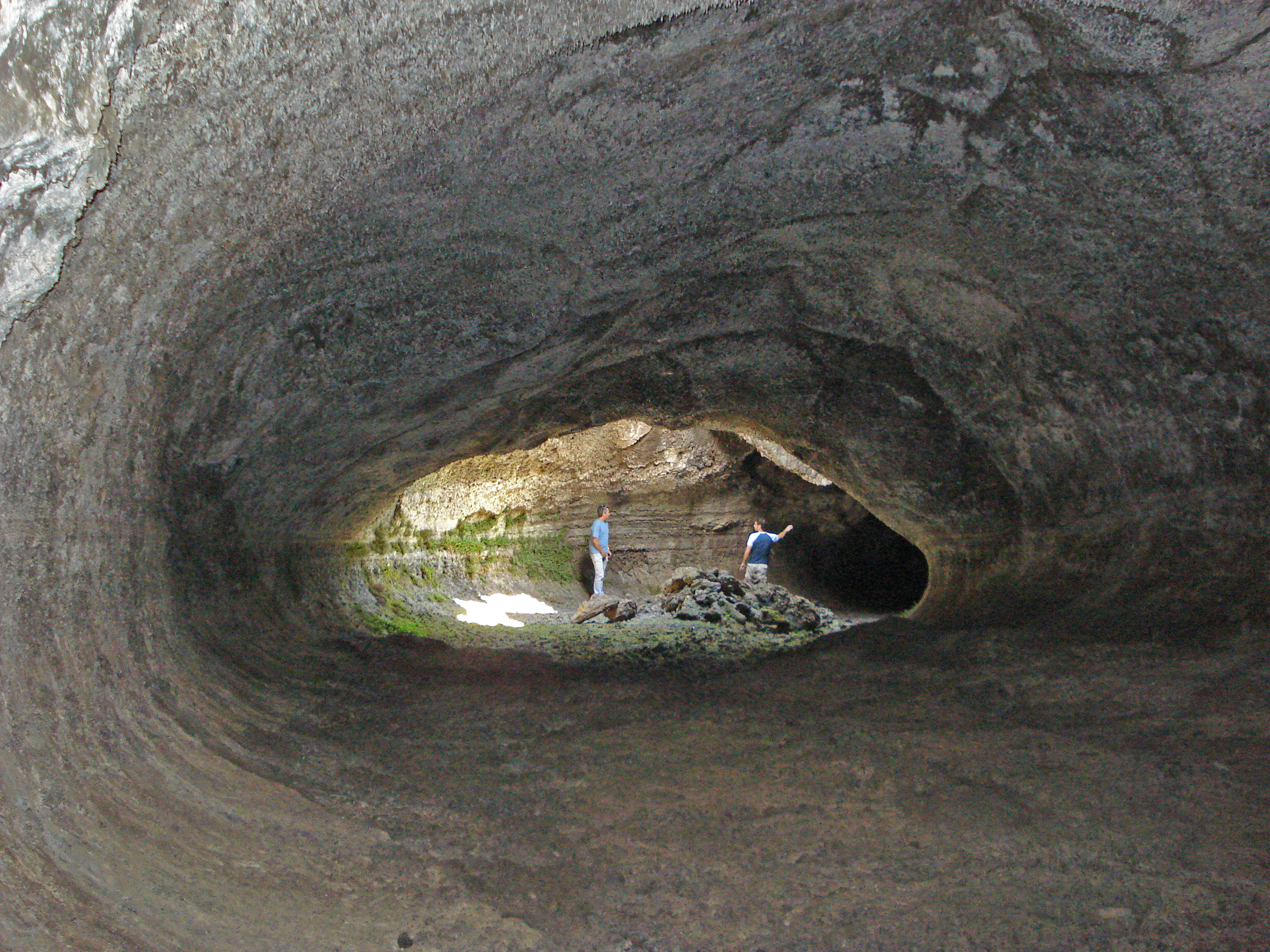
KM 11,2 – The road continues with the characteristic birch trees that now make their appearance. Shortly after the eleventh kilometer from Fornazzo here on the right is the path to the nearby Grotta dei Ladroni, reachable after not even 100 m. Located inside a beautiful field of Ethnic birches, this lava flow cave has several semi-vertical openings in the ground. The main entrance, which is the first one coming from the SR Mareneve, is characterized by a steep lava stone staircase carved into the rock. Once inside it is possible to walk the entire cavity almost completely. From one of the external openings stands a birch trunk that comes from the cave. The cavity owes its name to the legend that wants a band of thieves to take refuge on this site. Until the fifties it was used as a nivera.
KM 11,7 –
We are at the highest point of the SR Mareneve (1700 m.). Here there is a detour to the left.
Taking this detour after 800 m. on the right we find the entrance to the wonderful Sartorius inactive craters; after 1.1 km on the left the entrance to the Pineta della Cubania; after 1.9 km on the right the entrance to the Serra delle Concazze path; after 2 km the road ends at the Citelli Rifugio (with manager, property of the CAI). Here you can refresh yourself.
KM 12,9 – You walk among beautiful panoramas of 1865 lava fields, the summit craters on the western horizon and the sea on the eastern horizon. A road crosses on the left. It is a closed road that ends after 800 meters, near Monte Baracca. From here starts a beautiful trail to Monte Frumento delle Concazze, whose conquest is hard but will make you happy for the rest of your life!
KM 13,5 – We are at 1550 m. and the road crosses the bed of the Sciambro (or Quarantore) stream. Here there are two small paths: on the right, the one that even after 800 meters, reach the summit of the Secondo Monte (which is one of the so-called Due Monti). The 360 ° panorama is superb. On the left, instead, you can get to the Primo Monte.
KM 14,4 – All of a sudden the scenario changes abruptly. You can see the signs left by the 2002 eruption. The view of the sea and the distant Peloritani Mountains, the northern limit of the Alcantara valley, is superb. On the left deviation for Piano Provenzana, which is reached after 3 kilometers. Here there are shops, restaurants and the ski lift for skiers.
KM 14,8 – Another detour to the left for Piano Provenzana. Then the road slips into the superb Pineta Ragabo.
KM 16,8 – Between woods on the right and left the road meets some shelters and small inns. Here, on the left, is the detour to the beautiful Altomontana, a forest road that winds around the volcano in a north-west-south semicircle.
KM 16,9 – On the left, detour to the Grotta Corruccio path.
KM 19,1 – On the right, is the entrance to the Lava 1865-Due Monti path.
KM 25,9 – On the left the detour for the Quota Mille road, a typical road that stands at 1000 m asl approaching, after almost 20 km's during which you can enjoy terrific views of the top, of the Peloritani mountains , the Alcantara valley and many lava flows of the past, the nice town of Randazzo
KM 30 – Linguaglossa.

THE SONS OF ETNA
Commonly called "sons of Etna", there are hundreds of inactive craters around the volcano and demonstrate the thousands of eruptions that occurred over the 5000,000 years of the volcano's life.
It is a wonderful experience to climb on one of them and go around it
Let's find out some.
Monti Sartorius: Etna Northeast , 1700 m asl
Perhaps the most famous "bottoniera" so that a series of extinct craters, in a row like the buttons of a shirt, formed during the eruption of 1865. The underlying lava field is rich in lava bombs, witnesses to the Strombolian eruption formed during the explosive activity of the eruption (typical of Etna).
Degree of difficulty: medium - Duration excursion A / R: 1 hour
Monte Frumento delle Concazze: Etna Northeast , 2150 m asl.
The largest of the extinct craters, formed during the 1865 eruption, difficult to climb. Very arduous ...
It is so called because inside the Astragalus, with its yellow tufts, makes it seem rich in wheat (frumento in Italian). From its top the underlying Sartorius look like golf holes!
Degree of difficulty: difficult Duration of excursion: 3 hours
Monte Nero: Etna North, about 2000 m asl.
See above (Piano Provenzana).
Degree of difficulty: medium Duration excursion A / R: 2 hours
Volcano of Mojo: Etna North, 700 meters.
Inside the village of Mojo Alcantara, easy walk that can be added to the Alcantara river excursion
Degree of difficulty: easy Duration excursion A / R: 1 hour
Silvestri Craters: Etna South 2000 meters.
Certainly the most famous. See above (Piazzale Sapienza).
Degree of difficulty: easy (lowest), medium (highest)
Monte Ilice: Etna Southeast, 870 meters.
Close by the town of Trecastagni. From the top the view is splendid, especially over the sea of Catania. His crater, from which one day he puffed ashes, lava and lapilli is now full of trees. Monte Ilice is an inactive volcano formed, according to some, during the 1393 eruption that reached the sea near Pozzillo. Go up the mountain from the west side through a natural road that crosses a splendid forest of oaks, holm oaks and brooms.
Degree of difficulty: easy Duration excursion A / R: 1 hour
Monte Serra: Etna Southeast, 450 m asl
Inside the town of Viagrande. Its interior, once also full of fire, is now a vineyard. Formed in the mists of time ... The view is splendid, especially over the sea of Catania. Inside Monte Serra is the very special "Butterfly House" a house with insects from all over the world.
Degree of difficulty: easy Duration excursion A / R: 1 hour
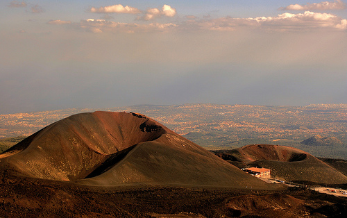
Monti Rossi: Etna South, 950 meters.
Vulcano formed during the 1669 eruption that arrived, mostly destroying it, up to the city of Catania. From the top it is easy to understand the path that the lava had to make. Currently this extinct crater (which seen from a distance would seem two) is covered by a lush pine forest. Designed by all seven and nineteenth-century travelers.
Degree of difficulty: easy Duration excursion A / R: 1 hour
Anello della Grande Quercia: Etna ovest. See below
THE VALLE DEL BOVE
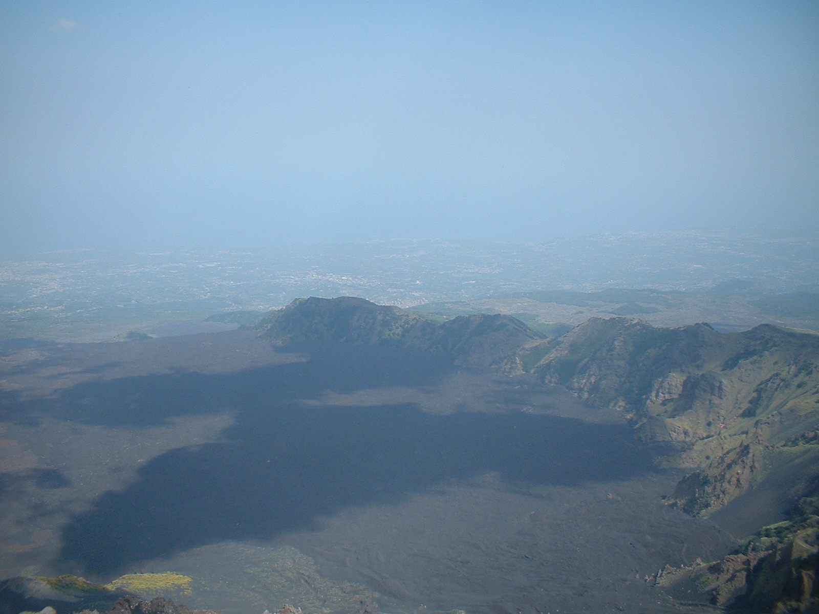
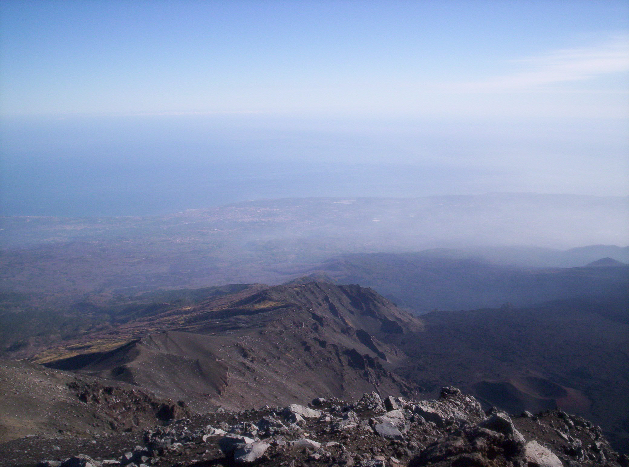
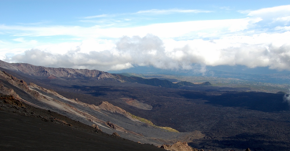
Very suggestive, perhaps the true postcard of Etna, here is the Valle del Bove, an atypical emergency for a volcanic complex: it is a very deep and vast depression of the eastern part of the "mountain of fire", a huge black valley! !!
The interior is rich in millenary lava flows (but also the recent ones are drived into this enormous depression) and dozens of extinct volcanoes that draw this impressive and vast black ocean. Several observation points from above which, during an eruption, become the visitors' favorite vantage point.
Following are the most important observation points:
Monte Zoccolaro: Etna Southeast, 1700 m asl. It is accessed by taking the SP92 Marenevefuoco from Zafferana. After 9 kilometers, on the right, it is a deviation that after 5 kilometers reaches its final point. Here is a small path that immediately goes up to Mount Zoccolaro to the right which is reached after about 1 hour walking in the woods. The hike starts from a well-trodden path that crosses a grove of Aspen trees that alternate with Chestnut trees, cultivated fields, bracken, large canine rose bushes, hundred-year-old Beech trees and Brooms. The path is a bit steep but it is worth the walk as it allows you to admire breathtaking views with views of the Val Calanna, the eastern slope of Etna, the Peloritani, Calabria and the Iblei. At the top is a cross and an altar. From here you can enjoy a splendid view of the Valle del Bove
Degree of difficulty: medium Duration excursion A / R: 2 hours
Val Calanna: Etna east, easily reachable from the town of Zafferana. It is an itinerary that allows you to reach the final stretch of the Valle del Bove, right inside it and therefore does not have the typical panorama of the itineraries to follow. It is accessed by a path that starts from the normal paved road and exactly from where the lava flow of 1991-93 stopped and whose black snake, a time of fire , is still seen descending from the valley. An altar (one of many) was placed by the faithful as a sign of thanks for the lava flow stopped. From here, in less than an hour, one arrives in this valley, rich in flora until 1991 and today covered for the most part by the lava of that flow.
After the first few meters, both the flow of 1852 (to the north) and that of 1991 (to the east) can be seen immediately.
At the edge of the path you can still see the signs of the previous plant landscape dotted at the bottom with typical orchards (pometi, cherry trees, etc.) replaced at high altitude by small vegetational islets ("dagale") surrounded by the lava flow of the past.
As you get closer to Monte Calanna the landscape is dominated by a beautiful field of broom.
Degree of difficulty: easy Duration excursion A / R: 2 hours
Monte Fontane: Etna east, 1280 m asl. It is one of the easiest points to reach in order to observe the Valle del Bove. It can be reached after traveling 4.7 kilometers of the SR Mareneve Fornazzo-Linguaglossa (starting from Fornazzo), at the Casa Pietracannone (a refuge). From here on, continue in a southerly direction (a road next to the Refuge) and, walking on a lava field, climb to the top of the mountain.
Degree of difficulty: easy Duration excursion A / R: 1 hour
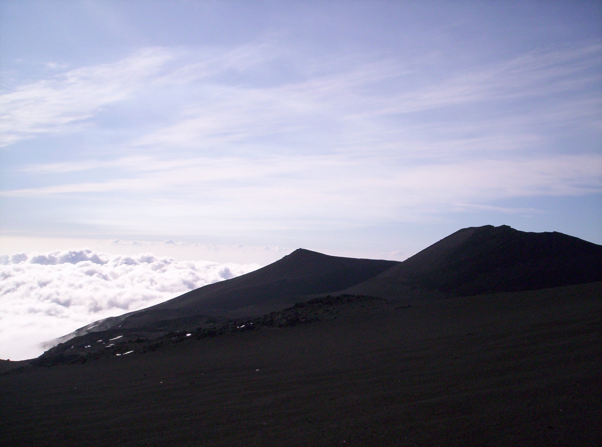
Pizzi Deneri: Etna north, 2900 m asl, really a step away from the top. You can get there from Piano Provenzana, which is about 11 kilometers away. It is a titanic undertaking, after about 4 hours of robust walk on the lava desert.
From Pizzi Deneri the Valle del Bove is a unique and exciting show. A long black trail, huge and full of extinct craters, with the breathtaking view of the sea and the mainland.
One of the most beautiful (and arduous) paths to get there is the one that starts from the Citelli Refuge and goes up to the northern crest of the Valle del Bove (Serra delle Concazze, 2400 meters).
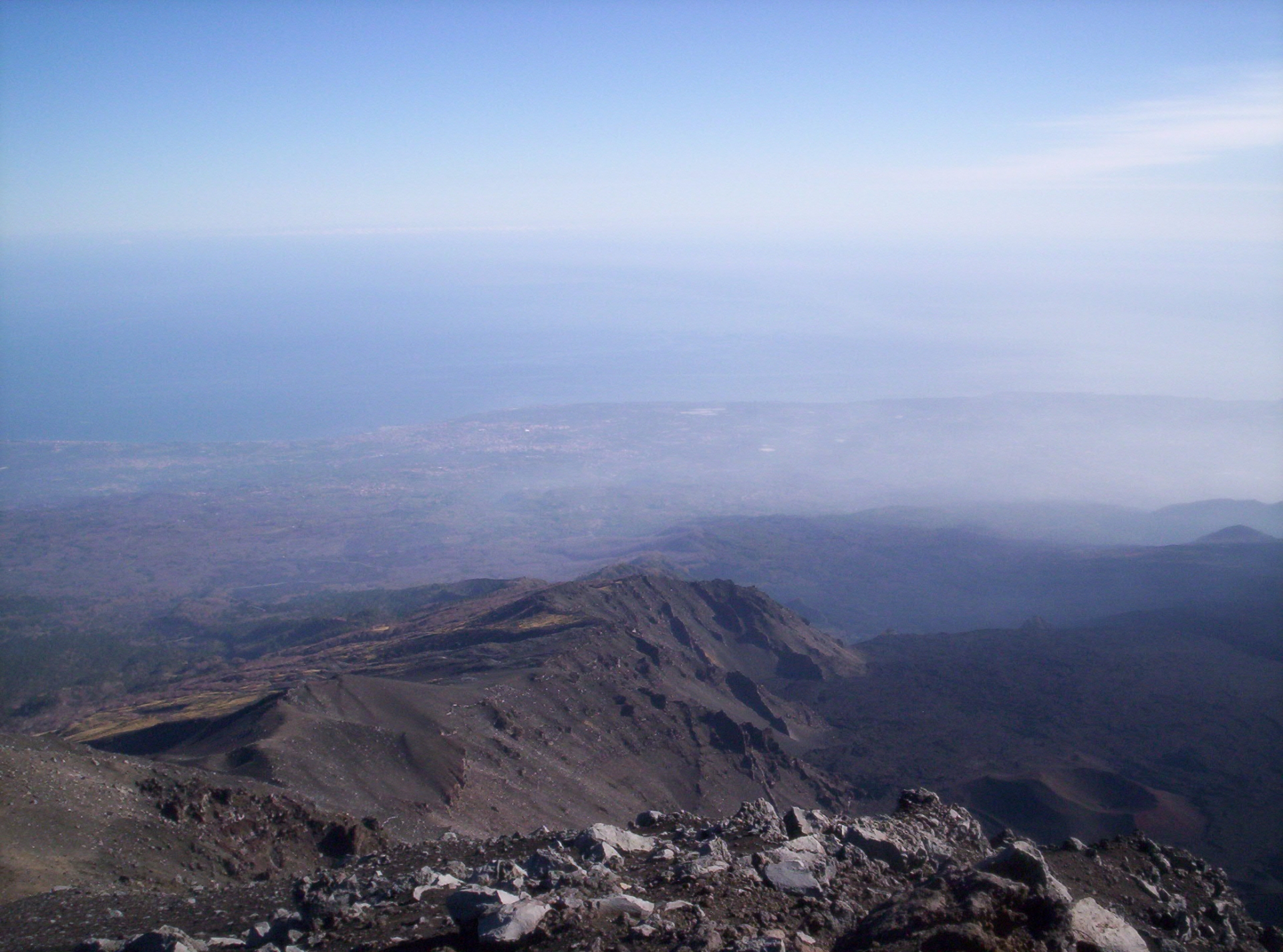
Certainly one of the most suggestive experiences given by the Sicilian giant. Unforgettable the spectacle offered by the wonderful views of Etna: the black valley at hundreds of meters of dizzying depth; the lava desert; the summit craters to the west;
the panorama of all the other cones turned off here and there. In this almost surreal scenario we arrive at Pizzi Deneri: an expanse of black sand filled by the white domes of the Volcanological Observatory, a setting worthy of a lunar set. The right conclusion to a journey into the fantastic. Spectacular return, on the contrary, with the sea in front.
Degree of difficulty: difficult Duration of excursion: 5 hours
La Montagnola: Etna south, 2500 m asl. Is the area from where the Valle del Bove begins. You get there or after walking for about 3 hours from Piazzale Sapienza or after taking the cable car that arrives right here in less than 20 minutes. The view is excellent with all the extinct craters of the valley that are spread to your terrified look.
Degree of difficulty: difficult (if on foot) Duration of excursion: 4 hours
Schiena dell’Asino: Etna south, 2100 m asl. Access is in the SP92, about 2 kilometers from Piazzale Sapienza towards Zafferana. Here, on the left, is the entrance to this path which, after about 2 hours of walking, between the initial woods followed by the lava desert, arrives in this marvelous and enchanted panorama over the valley.
The trail begins immediately uphill among the pines and brooms, ready to get around Mount Salifizio to conquer the Valle del Bove.
With a little attention you can see at the top the botton-shaped mouths of 1892 and at the bottom those of 1792. After about 2.5 kilometers you reach the highest point: the Bove Valley extends at the feet of the visitor in a scenario between most magnificent on Etna.
Schiena dell'asino is right at the beginning of the valley, forming the highest summit of its southern wall. To the west, from left to right, we see the Montagnola and the 2001 crater (between the two the Canaluni 'a rina, the passage to go down to the valley); higher up the smoking peak of the volcano.
Facing (north), the other border of the valley consists (from left to right) of: Pizzi Deneri, Serra delle Concazze, Serracozzo, Monte Rinatu, Monte Scorzone, Monte Cerasa, Monte Fontana and Monte Cagliato. To the east is the Salto della Giumenta and Monte Calanna. Under our gaze the Valle del Bove opens up even more astonishing with a series of extinct craters scattered here and there.
Degree of difficulty: medium Duration excursion A / R: 3 hours
Minte Scorsone The route starts from SR Fornazzo-Linguaglossa, northern Etna, 6.5 kilometers after Fornazzo. We are at about 1300 meters above sea level and on the left a small indentation with a typical forest gate indicates the entrance to the Pineta della Cubania, the starting point for various itineraries. Here you can admire a luxuriant mixed vegetation as chestnuts, pines, holm oaks, beeches ... After a little more than a kilometer, the cart track is crossed by the lava flow of 1928 (already colonized by pioneer forms of vegetation) and by that of 1971. The panorama suddenly overlooks the top of the volcano (to the west) and the Ionian coast (to the east). Then you enter the woods again and arrive to a refuge (Case Paterno Castello). After about another km you can see a huge boulder on your left, right on the roadside. And from here begins (very visible) the path that leads up to Monte Scorsone (after about 40 minutes of good climb). Sometimes the path seems to divide but then it rejoins and therefore there is no possibility of making a mistake. In any case, always keep to your left, ie go south. The view over the Valle del Bove is amazing once you reach the top.
Degree of difficulty: medium Duration excursion A / R: 3 hours
WHAT ETNA CREATED IN MILLION YEARS
A volcano creates and destroys with the speed of a child.
Let's take a walk through the millennia and see some "works" created by the artist Etna.
The salinelle
The Salinelle (also called maccalube) are three fields of conical mud volcanoes, located in the municipalities of Paternò (Salinelle dei Cappuccini or Stadio and Salinelle del Fiume) and Belpasso (Salinelle di San Biagio). They have a certain relationship with volcano eruptions.
In fact the Salinelle present a sort of restlessness, a greater intensity and boiling before an eruption (as was observed in 1999, 2001, 2002, 2004 and 2006). On these occasions, significant quantities of hot mud (30-40 ° C) have erupted, which in the summer of 2006 caused significant damage to nearby citrus groves. The Salinelle, in the past, were used to cure pains in the limbs and sprains of horses, for foot baths and for rheumatic pains.

The Timpa of Acireale
It is a long lava ridge that for almost 7 km drops down over the sea, even more than a hundred meters high, covered with ivy, euphorbia and carob trees. Together with the island Lachea, it constitutes a natural open-air laboratory in which the geovulcanic history of Sicily is written. Of particular relevance some stretches close to the coastal strip, where high basaltic colonnades, similar to those present in the Alcantara Gorges, represent the path of crystallization of the lavas in contact with water.
This is the case of the Grotta delle Colonne, reachable only by sea. Several birds of prey nest in the area, and undisturbed dense vegetation grows luxuriantly thanks to the springs that flow into the Ionian Sea. As in Santa Caterina, characterized by a belvedere with a splendid view. The Chiazzette path, in Acireale, a stone walkway that can be reached (paying the utmost attention) from SS114 road, is a seventeenth-century route that leads down to Santa Maria La Scala, a picturesque and peaceful seaside village.
Along the zigzag path of Le Chiazzette, we will encounter the Fortezza del Tocco, a fortress in defense of Acireale in the seventeenth century, during the Spanish domination, from which a cannon shot was fired to warn of danger.
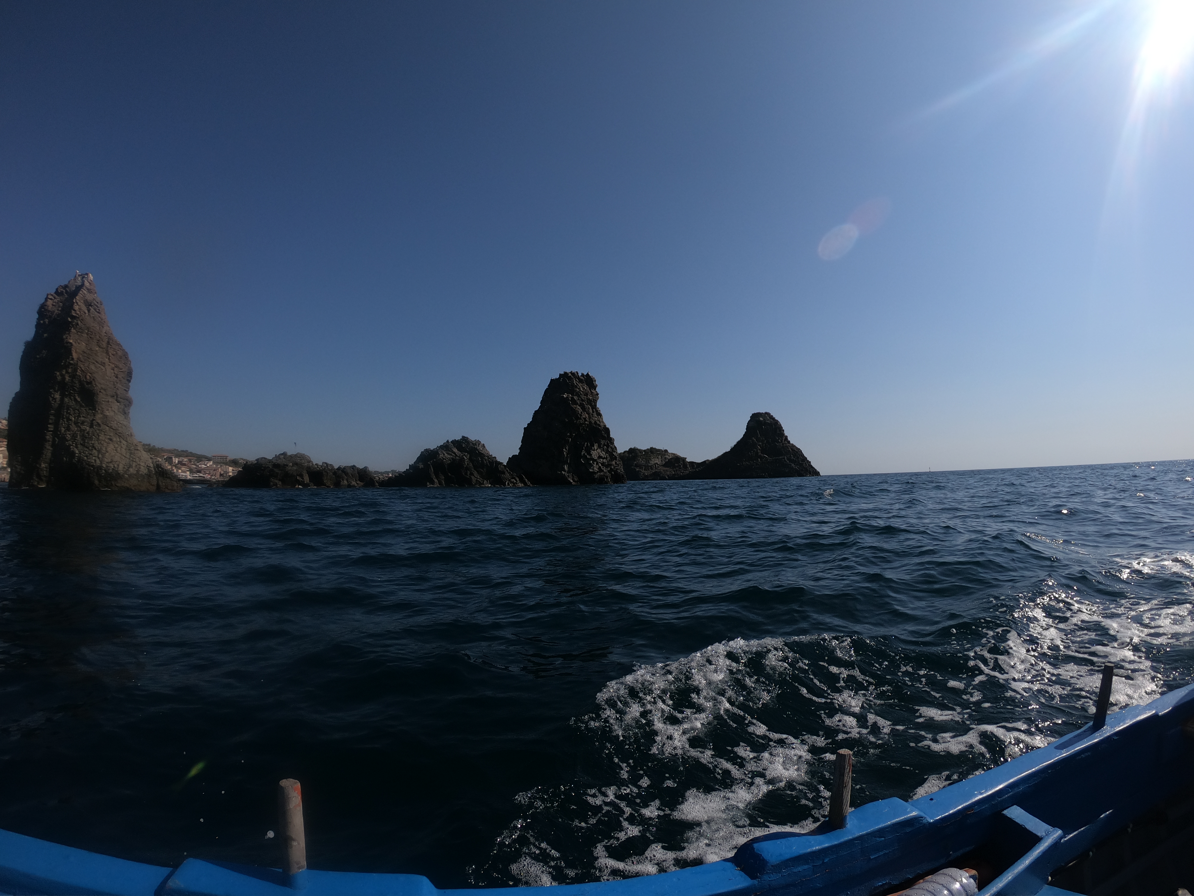
Lachea island and the Faraglioni of Acitrezza (I Ciclopi)
Area of great charm.
We are in the seafront of Acitrezza, a fishing village at the foot of the volcano.
The spectacular Lachea island, right in front of the promenade, consists mainly of basaltic rocks and it is the largest of the Cyclops Islands, of volcanic origin linked to the first submarine eruptions in the Gulf of Acitrezza , dating back to around 500,000 years ago. The archipelago of the Ciclopi is a site of great interest both naturalistic and archaeological, in fact on the island Lachea were also found evidence of human presence dating back to prehistoric times.
Almost caribbean is the richness of the seabed where, among others, it is possible to admire arborescent colonies of polyps that can exceed even the height of one meter, but among all those that stand out for their singularity and beauty is the Alicia mirabilis, the largest Attinia in the Mediterranean. The fauna of the Lachea island is quite varied. Among the numerous invertebrates we find the exclusive presence of the endemic lizard Podarcis sicula ciclopica.
According to legend, the origin of the island is attributable to the boulders thrown by Polyphemus against the ship of Ulysses-Nobody (Homer, Odyssey).
Castagno dei 100 Cavalli (Chestnut of 100 horses): Etna east, near the village of Sant’Alfio. Symbol of the Etna trees, with its millennial longevity. A circumference of over 22 meters makes it the largest chestnut in the world. Etna, incidentally, is rich in centuries-old trees (especially oaks).
Alcantara river
The Alcantara river (Akesines for the Siceliots and Onobola for the Romans) born in the Nebrodi Mountains (near Floresta), close to the northern part of Etna, and continued its journey along the entire north side until it led to Giardini Naxos . During his journey "the bridge" (al qantarah, in Arabic) is often in contact with the lava rock.
To be precise, his first encounter with the hard and black basaltic rock occurs in the low vineyards of Castiglione di Sicilia, at the height of the stunning Byzantine Cuba. When the water meets the lava stone it begins a work of erosion that in this case, given the consistency of the opponent, is very surgical and long. This struggle, after several millennia, has led to the formation of spectacular canyons, famous throughout the world: the Alcantara Gorges.
Simeto river
"From Adernò to Catania, nature is the earthly paradise of Sicily. There is a vigor of vegetation, a profusion of greenery, an abundance of water like no one can see elsewhere ". Thus documented Charles Didier on a visit to Sicily in 1829, and Father Onorato Colonna, in his 1738 manuscript Adernò Redivivo, stated: "The greatest value that the territory boasts is the celebrity of the Simeto river".
Between rugged stretches of lava, lush citrus groves and wild vegetation, the Simeto river digs the lava stone determining waterfalls characterized by spectacular columnar basalts.
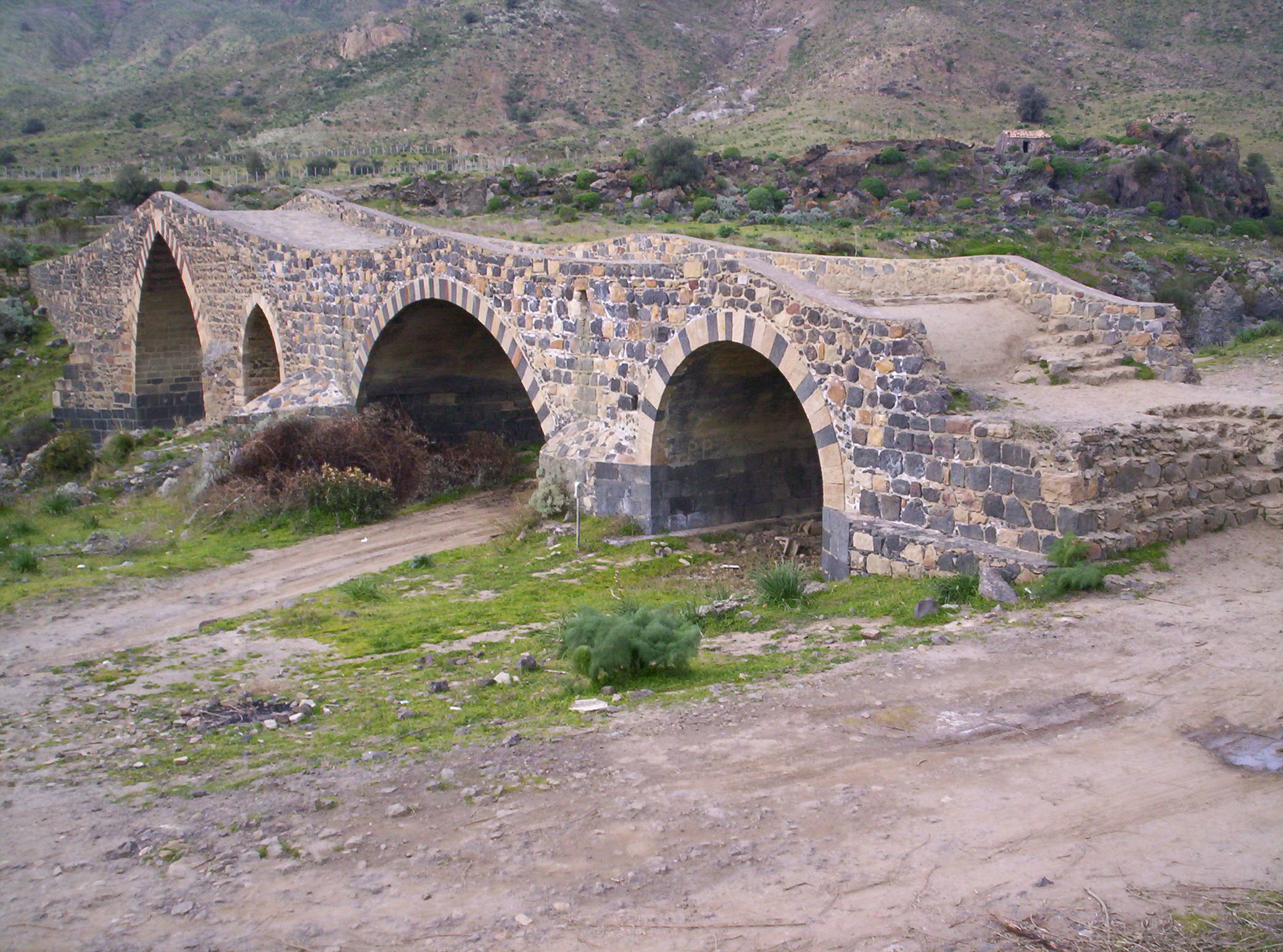
The Simeto surrounding were inhabited from prehistoric time and we can adimre many ruins of the past as the stunning Ponte dei Saraceni (photo)
The nivere
The nivere were sites where the snow accumulated in order to use it in the summer for storing food or something else. Many caves (especially here in Etna area) had its nivarolu (worker of the snow). Etna was certainly a very favorite place for this
kind of work that could count on an innumerable number of caves, already in itself excellent snow preservers and never touched by the sun.
The snow, became ice, was cut into pieces and transported on the back of a mule to Catania to be sent by sea, even to Malta. It was used in the butcher's shop, in the hospital to treat some diseases, to refresh and preserve drinks and food, as well as for the production of ice cream and granita.
Lava stone: 3000 years of use
The variety of stones is one of the great surprises of Sicily that is added to that of the colors, proverbial, of its sky: white Sicily (limestone) to south; Sicilia red and yellow (sandstone) to the north; black Sicily (lava stone) to the east.
This variety meant that the prehistoric tools of a large part of the island modeled on flint or quartz in the Etna area were also found in basalt; that the Roman forum in Syracuse was all in limestone and the coeval baths of Catania in lava stone; that the baroque of Noto presents portals in limestone, that of Palermo in sandstone and that of Catania in lava stone. The stones at that time were very expensive and they were carried on the backs of the mules.
Urban buildings A good part of the buildings of the Etna villages is made of lava stone. For the important constructions (churches, palaces ...), large squared blocks of lava stone were used; rural country houses, extraordinarily still present in the agricultural landscape, were built by placing one stone on the other. And still today they stand there, strong and solid than ever.
The roads On the slopes of Etna there are still some ancient roads in lava stone with the characteristic "ciacata" made with pebbles of lava stone. Of course the carriages had to be pretty sturdy to walk on these roads of antiquity!
The"palmento" The "palmento" wasthe place where the grapes were pressed to produce the "mosto" that was stored in large tanks. Entirely made of lava stone, today it has become a living room for renovated dwellings. It is the most romantic and sober architectural element of the Etnean landscape. There are still so many "palmenti" around in the Etna countryside. We hope they last as long as possible.
It stands on two levels. An external staircase reached the second level which had no doors but only a window that connected to this staircase. The farmers gathered the grapes in baskets and emptied them into the "palmento" through this window. Here the grapes were pressed by feet and through channels cut into the floor, was poured into a stone tank placed on the first level.
THE PISTA ALTOMONTANA
Exceptional route of 36 kilometers that goes around the volcano, at the constant altitude of 2000 meters, describing a north-west-south arc. You can travel on foot or by bicycle and during this journey you will meet different shelters open to all, lava flows of the past, woods, caves, extinct volcanoes ... It is the naturalistic route on Etna par excellence, for it embraces everything that has to be seen.
But it is also the hardest and requires, if you want to do everything, at least a couple of days of good walks.
Starting from the Pitarrone Caserma (but if you prefer you can also start from the opposite side), which is on the SR Mareneve Fornazzo-Piano Provenzana-Linguaglossa (17 km after Fornazzo or, if you prefer, 13 after Linguaglossa) at the Ragabo refuge, let's walk the Pista Altomontana

KM 0 - 16.8 km after Fornazzo (or, if you prefer, 13.2 km after Linguaglossa), on the SR Mareneve from Fornazzo to Linguaglossa, at the Ragabo Refuge it is the entrance to a dirt track that enters the Pineta Ragabo. The sequence of giant pines is spectacular. After 1.5 km, on the right, a deviation leading to the Caserma Pitarrone refuge. Continue straight ahead and after 200 meters a Forestry bar indicates the entrance to the Altomontana Trail.
KM 0.1 - Immediately the road plunges into the recent flow of 2002. To the north you see the outline of the Peloritani that delimit the valley below, that of the Alcantara river. Beautiful foreshortening that, in truth, so much foreshortening is not.
KM 0.5 - You enter a mixed forest of beech and chestnut trees that survived the 2002 eruption.
KM 0.8 - We are on the lava of 1923 and on the right still the beautiful panorama of the Peloritani. Some pines begin the colonization of the lava flow. In the northern background, in relief on the Peloritani mountain range, the unmistakable peak of Rocca di Novara.
KM 1,2 - Small equipped area and entrance to the Monte Rossello path. Then the road still comes out of the woods and plunges into the 1911 flow.
KM 4 - Between brooms and splendid panoramas you reach a crossroads: on the left it leads to the Timparossa open hut; to the right it goes down to Grotta delle Palombe. We continue straight (west).
KM 4.5 - On the right the path to Grotta delle Femmine inhabited since prehistoric times, accessible through a 4-meter well. On the walls there are typical curved lavas.
5.1 KM - After leaving the wood, you are immersed in the spectacular lava flow of 1614 that lasted 10 years.
KM 5.8 - 1700 m. asl. On the left, detour to the Timparossa Refuge (after about 1.5 km). Continue straight ahead to the Altomontana.
6.0 km - Passo dei Dammusi: exemplary scenery of the lava cordate of the 1614-1624 flow.
KM 6,7 - The Altomontana enters a kind of kingdom of gnomes: a spectacular beech forest. With some pine and poplar. Beautiful contrasts (frequent in Etna) between vegetation (symbol of life) and black rock (symbol of death).
Km 7,7 - Monte Santa Maria Refuge.
KM 8.5 - Always in this unforgettable beech forest, a crossroads on the left not to be taken (even if it then joins this road).
KM 9.5 - Always in the woods. The road begins a steep descent.
KM 10 - On the right a curious lava stone house. Excellent in case of rain.
KM 10.5 - We see the town Randazzo
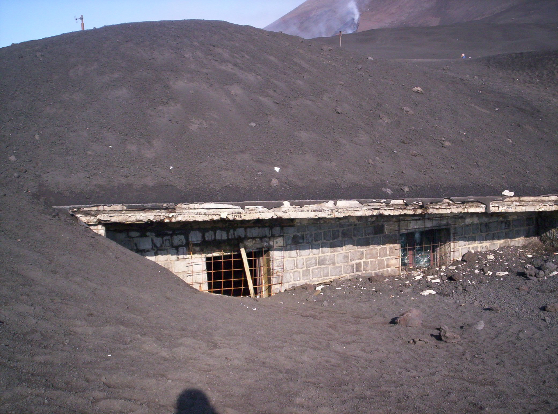
KM 11.2 - On the left the old road interrupted by the 1981 lava that arrived at Monte Spagnolo.
KM 12.2 - In the woods the Saletti Refuge. On the right the road leads to the Cisternazza. We are at about 1350 m, the lowest point of this road.
KM 13.2 - On the right the detour to Pirao.
KM 13.5 - We are on the 1981 flow just colonized by the first herbaceous plants.
KM 14.5 - Just before returning to the woods, on the right at the bottom, you see some lava mouths of 1981.
KM 15.1 - On the right detour for Monte Piluso. Always on the right you see Monte Spagnolo.
KM 15.3 - On the right the refuge of Monte Spagnolo and on the left the Casermetta. Beautiful wooded area. We are now in a pine forest.
KM 16.2 - There is a detour that on the right leads to Monte Piluso. The Altomontana continues on the left. Now we walk into a lava flow of the past
KM 18.4 - We are in the Bosco di Maletto. On the right, detour to the mountain and Rifugio La Nave.
KM 21.6 - On the left, detour to Monte and Rifugio Maletto. Always in a beautiful mixed forest of beech and pine trees.
KM 22.1 - On the right hand side deviation towards Poggio del Monaco, Case Pappalardo ...
KM 23.0 - 1750 m. We are on the west side of the volcano and enter for about 100 meters in a lava field. On the left, high up, majestic, the beech trees that reach the highest area in Europe (about 1800 m.).
KM 23.2 - On the right small path for Monte Egypt, Monte Lepre and Monte Rosso.
KM 23.5 - A grandiose landscape surrounded by the lava of 1759. On the right a series of "sons" of the Etna that from north to south are: Monte Egypt, Monte Lepre, Monte Nuovo (fibroso, that is: covered by volcanic sand), Monte Rosso, Monti De Fiore I and II and Monte Nunziata (the latter three are completely treesless).

KM 24.2 - We are at the Monte Scavo Refuge and on the right the path to Monte Egypt. At the top, very black, the wake of the 1999 lava flow.
KM 25.4 - Close to the track, on the right, the Grotta di Monte Nunziata and the beautiful mountain of the same name.
KM 26.2 - Crossing the 1999 lava flow you enter a birch trees forest and on the left is a beautiful haystack.
KM 27.9 - Poggio la Caccia Refuge (or Palestra).
KM 28.2 - We are at the highest point of the Altomontana, about 1950 m asl, between Monte Palestra and Monte Fornello.
KM 29 - Galvarina Refuge. Turn right for Piano Ginestre, Monti De Fiore.
KM 29.6 - The Altomontana enters a lava field.
KM 31.7 - The road loses height and enters a mixed forest which then becomes only a pine forest (Pineta di Biancavilla).
KM 34.4 - Rifugio Menza and (through a detour to the left) the Nuova Gussonea Botanical Garden owned by the University of Catania and closed by a mighty gate.
KM 36 - Milia Gate: southern limit of the Altomontana.

Summit craters
To reach the summit you have to walk the so-called Mount Etna Summit Trail, avoiding to venture into useless, tiring and extremely dangerous secondary roads (practically invented by you).
It can be taken either from the southern slope (Piazzale Sapienza, 1900 meters) or from the northern slope (Piano Provenzana, 1900 meters). In less than 5 hours the game is done (a couple for the descent). At the top there are 4 craters: the North-East (formed in 1911); the South-East (1971); the Centrale or Voragine (1787) and the Bocca Nuova or Voragine Ovest (1968).
The perimeter of the summit is about 1700 meters.
Sulfur is an annoyingly present component at these heights and is perhaps the only element of annoyance beyond the wind.
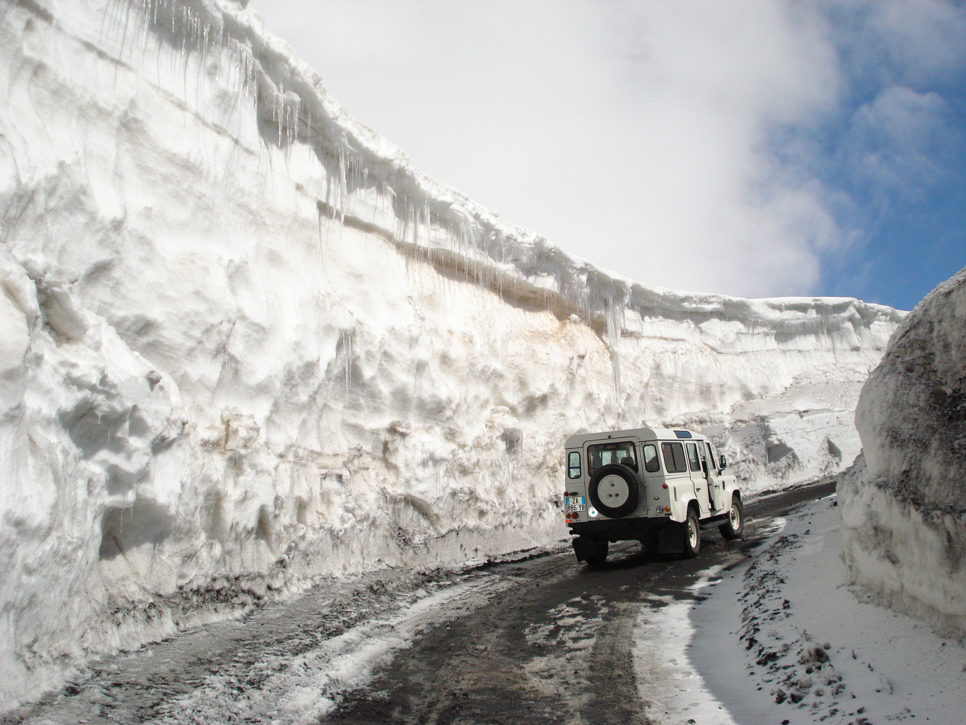
Do not venture to the top if you are not previously informed about the weather conditions. In any case it is advisable to reach the summit in the period from mid-June to mid-October, when there should be no snow.
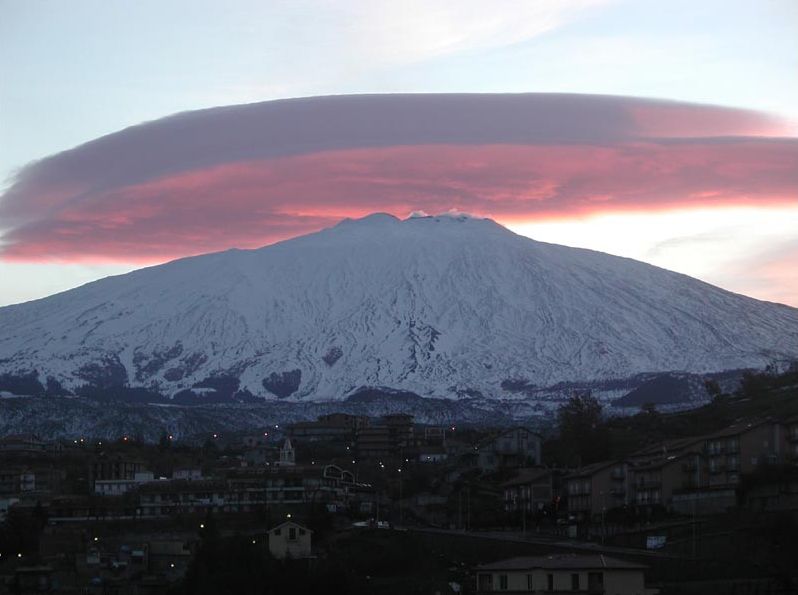
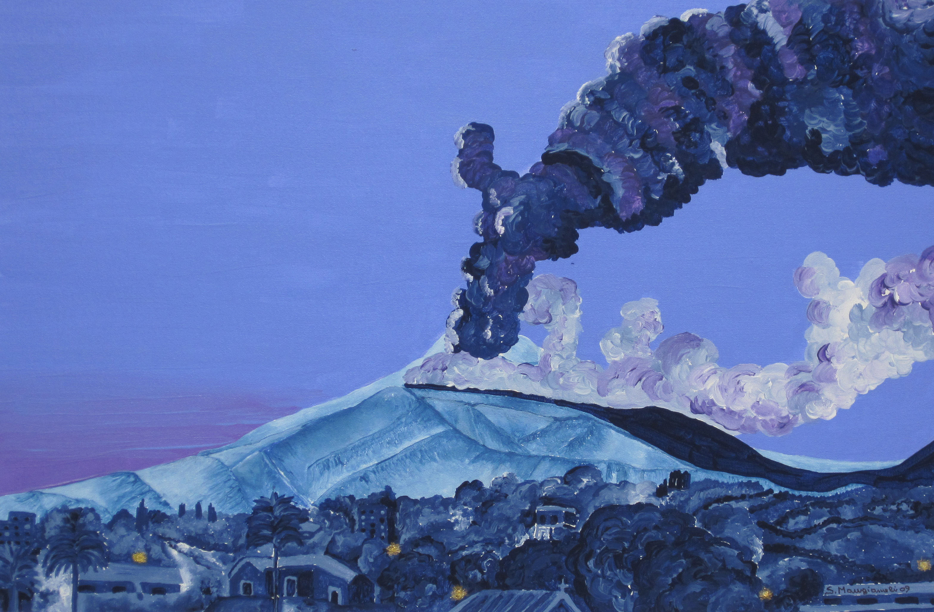
The Etna on the top often has a characteristic cloud cap to which the Etnei folks have given the name, genially, of Contessa. Genially because this name derives from the fact that above the summit there is a dispute of winds (contesa in Italian), whose final effect is the formation of this crown of clouds.
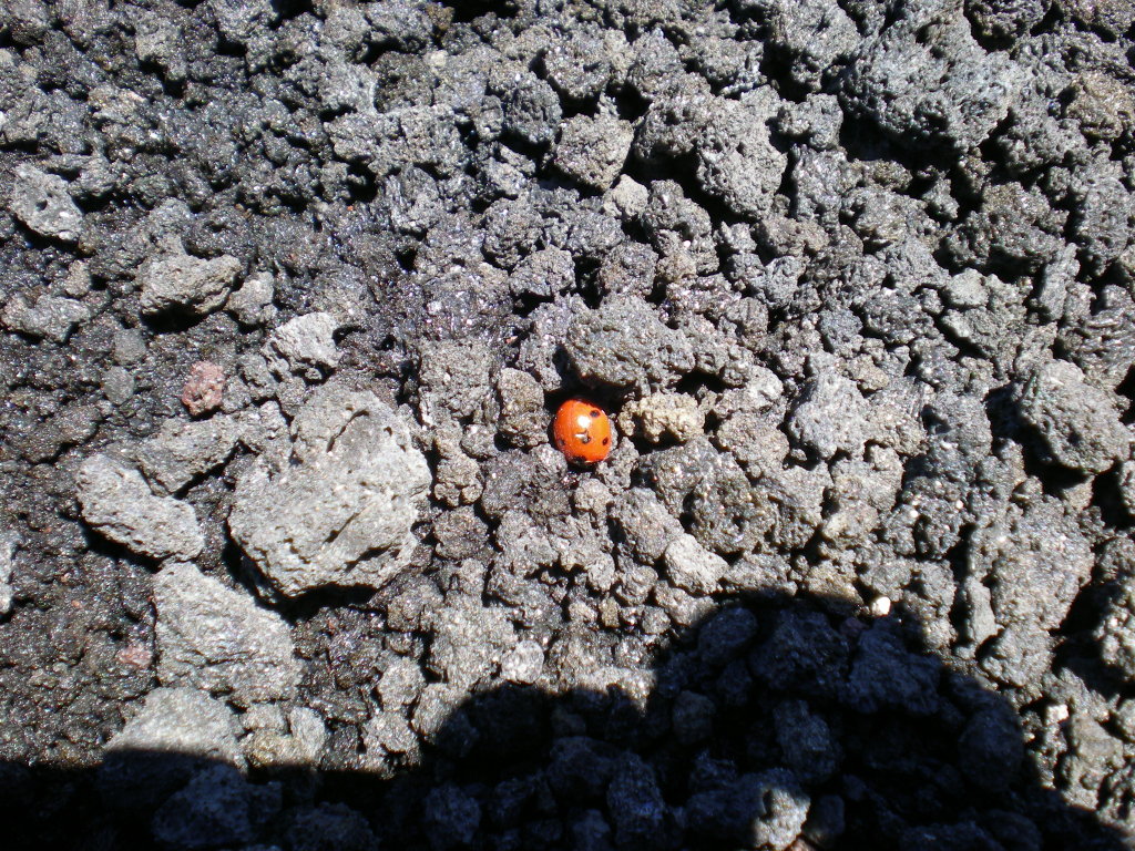
You will welcome, on the summit, from plenty of ladybirds that at 3300 meters find their ideal environment.
The cuisine of Etna (by chef Silvana Recupero)
On the slopes of the most majestic active volcano in Europe, a Muntagna as the locals call it with deference, there are numerous local productions. The typical product not only reveals its own peculiarity but also contributes to reconstructing ancient customs, activities and production methods that allow us to identify the personality of those communities. He also speaks of the typicality of a terrain influenced by the activity of Etna that gives rise to unique products with an incomparable flavor, irreproducible elsewhere. The people of Etna have maintained a very strong bond with the land and the tradition: a gastronomic tradition which is the result of a slow intercultural evolution. Heterogeneous civilizations that have left their mark also in the culinary tradition of the island, which dates back to 2500 years ago.
The arrival of the Greeks, the first settlers, took place in 735 BC in Giardini Naxos. They found fertile soil and plenty of fruit. The first authoritative gastronomic testimonies date back to the 4th century BC with Plato (arrived at the court of Dionysius the old) who boasted Sicilian pastries. Among the testimonies is the (lost) work of Miteco in Syracuse. The products arrived in Sicily from the Greek coasts are still visible in the current kitchen: garlic, olive, starch, basil, caper, cumin, oregano and chicory.
.JPG)
L
The Roman era (from the III century BC) was particularly difficult for the island. In this period of exploitation and abuse of power, the kitchen became much more frugal. The symbol of the Roman period is the maccu, whose name derives from "maccare" or "ammaccare": a puree of broad beans cooked in water flavored with aromatic herbs and seasoned with raw oil.
The Arabs (9th century) perfected agriculture by improving irrigation techniques, they taught farmers the cultivation of sugar cane, citrus fruits, prickly pears, cotton and jasmine. They introduced the use of new spices, such as cinnamon and saffron; of dried fruit both in desserts and in other dishes (raisins, pine nuts, almonds, pistachios); and they imported rice, a fundamental ingredient of arancini and crepes. But the dish that mostly refers to Arab culture is certainly the couscous.
In the Angevin period (XIII century) there are only a few important innovations: the falsomagro (stuffed veal roast); the use of short pastry, which transforms some dishes such as caponata or oven-baked pasta into timbales; and the use of flour to thicken sauces.
The subsequent long Spanish domination, or "Age of the Viceroys", characterizes the history of the island for several centuries. In the kitchen we find many products imported from the new world: tomatoes, peppers, corn, potatoes, beans, cocoa and vanilla. The Spaniards are also credited with pumpkin, wild fennel and aubergines. The traditional Etna cuisine is purely popular, essentially genuine and not contaminated by the splendor of the courts. The main role is played by the bread: a common habit was to knead the bread once a week, and each family had a large wood-burning oven in the house that was lit for that use. In the oven they made also a Scacciata, fish, vegetables, meat.
Many of these dishes date back earlier, according Archestrato of Gela (IV century BC) who mentione fish wrapped in fig leaves and cooked in a wood-oven.
And finally here is a small list of the culinary art of the people of Etna:
Appetizers of local products Salami; Pecorino produced since the Greek era, also called tuma (if fresh and unsalted) or primosale, after salting; Dried tomatoes; Cunzate olives (ie seasoned); Salted anchovies.
N.B .: Giuseppe Coria, in his text Profumi di Sicilia, notes that: "There is no tradition of appetizers in Sicily. [...] Until a few decades ago, the use of appetizers did not exist, not even in the so-called "rich" cuisine. Most of the dishes you see today were a side dish to certain dishes; or even constituted the middle plate (and often the only one) of the "poor" kitchen [...] ".
First courses Pasta alla Norma; Pasta with broccoli; Maccu (cooked beans reduced in paste); Pasta and fried zucchini; Spaghetti with squid ink; Pasta with breadcrumbs and anchovies; Pasta cu ’finocchiu rizzu (this is the Catania version of pasta with sardines from Palermo); Spaghetti Alla Carrettiera; Pasta and risotto with mushroom seasonings.
%20-%20Copia.JPG)
Second courses and side dishes Roasted, fried, marinated Masculini (fish) ; Stuffed squid; Sardinians in beccaficu in the Catania variant; Tuna with the cipuddata (onion); Meatballs in lemon leaf; Muccu meatballs (fish newborn); Falsomagro agglassatu; Catania Caponata; Roasted aubergines and peppers; Peperonata; Fried pumpkin flowers; Grilled artichokes; Gattò (mashed potato pie); Rocculi affucati (broccoli). Arancini (fried rice balls with sauce and meat, spinach or butter); Anchovy or ricotta crispelle; Scacciata with tuma, broccoli or potatoes; Sicilian pizza with tuma and anchovies ("Sicilian").
Desserts and ice creams Cassata siciliana (or the typical Catania cassatelle, smaller); Benedictine rice crispelle; Cannoli; Almond cake; Olivette di Sant'Agata; Pasta reale; Almond paste; Assorted pastas (dozens of types in all the best pastry shops); Granita (lemon, coffee, almond, mulberry ...).
Travelers of the "fantastic"
Etna aroused not a little attention among the peoples of the past. In those times, when the inexplicable manifestations of nature could only be explained by divinatory art, a fire-breathing "monster" of this size could not have gone unnoticed.
Thus, many characters from the fantasy world have stopped on our volcano. Here are some
Enceladus He is one of the Titans, the bad ones, son therefore of Gea (the Earth, grandmother of Zeus) fertilized by the blood of Uranus (grandfather). Like the other Giants, Enceladus was a creature half man and half beast: up to his thighs he had a human form, while in place of his lower limbs he had scaly snake tails. With the other Giants, Enceladus participated in the so-called Gigantomachy, the battle between the Giants and the gods of Olympus. These Titans put three mountains on top of each other to reach Olympus but were defeated. Enceladus tried to escape but the goddess Athena buried him by throwing him over the island of Sicily; the myth tells that the volcanic activity of Etna originated from the fiery breath of Enceladus, while the earth's tremors during the earthquakes, from its rolling under the mountain due to the wounds.
Typhon Like Enceladus, he was also buried under the ground. Also called Tifeo, it was a monstrous being with 100 snakes on its shoulders. According to the poet Eschilo, Tifone was confined to Etna. He was considered the father of impetuous winds (typhoons).
Hephaestus The greatest blacksmith of all time. He had the shop in the crater of Etna. His artistic works include: the arrows of Zeus; the belt of Aphrodite; the armor (and shield) of Achilles; the chariot of Helios; the armor and the helmet of Aeneas. His assistants inside the forge were the Cyclops; he also built metal automata that also helped him in his work. In Greek mythology he is the god of fire, of technology, of blacksmiths, of artisans, of workers, of sculptors, of metals and of metallurgy. In Etna was a temple of the god Adrano (often identified with Hephaestus) which was guarded by sacred dogs capable of identifying the goodness or wickedness of the faithful. Pindar calls Etna's explosive activity "jets of Hephaestus".
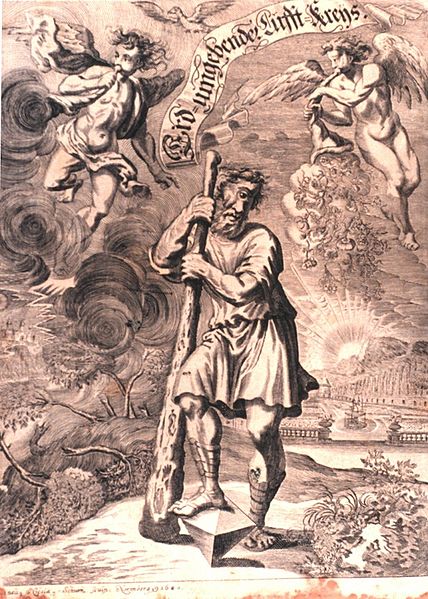
Cyclops Giant monocles, sons of Uranus and Gea. The most famous of these was Polyphemus, but the first three were Bronte, Sterope and Arge. They were brothers, and lived in the crater of Etna where they were practically employed by Hephaestus (see above). But let us return to Polyphemus, the leader of the Cyclops, immortalized by Homer. When the protagonist of his Odyssey, Ulysses, lands in Sicily, he is taken prisoner by this giant who lived in a cave on the slopes of Etna. Homer speaks of it in the Odyssey (book IX) when Odysseus meets the descendants of Bronte, Sterope and Arge in Sicily: the barbarian Ciclopi who, by now forgetting the art of their ancestors who worked as blacksmiths for Zeus, lived dedicated to pastoralism and isolated one from the other. Meanwhile Polyphemus eats three companions of Ulysses, who to escape make a plan: first of all he offers wine to the Cyclop who, thanking him before collapsing in his sleep, asks him his name. Ulysses replies that he is called Nobody, after which he blinds him with a red-hot stick and runs off with his companions. When the other Cyclops saw him with an eye full of blood and asked him who he had been, to the answer "Nobody", they clearly mocked him. A short time before, Polyphemus became legendary for having hurled huge boulders against the sheperd boy Aci killing him. The beautiful nymph Galatea was the reason for the dispute.
Poseidon (Neptune) When Zeus divided the world to his brothers and sisters, he assigned the island of Sicily to Poseidon, the bearded king of the sea. The notorious trident of Poseidon was made built by Efesto who had his factory inside the crater of Etna.
Zeus (Jupiter) Like parsley: everywhere. Zeus had many appellations including that of Etneo. His arrows were made on Etna.
Here, we have presented you some features of the highest volcano in Europe.
Etna is like the sea: fascinating but dangerous if it is underestimated.
Call us for any information before venturing into the higher areas giovannivallone@mammasicily.com